Itaguaçu geodata
Itaguaçu (Espírito Santo) is a populated place; located in Brazil in America/Sao_Paulo (GMT-3) time zone. With population of 8,201 people, there are 1762 cities with bigger population in this country. Compared to other cities in Brazil, 55.9% of cities are located further ↑North; 70.6% of cities are located further ←West and 68.7% of cities have higher elevation than Itaguaçu. Note1


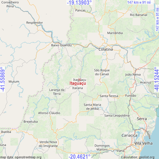
Itaguaçu GPS coordinates[2]
19° 48' 6.984" South, 40° 51' 20.016" West
| Map corner | latitude | longitude |
|---|---|---|
| Upper-left | -19.13903°, | -41.55869° |
| Center: | -19.80194°, | -40.85556° |
| Lower-right: | -20.4621°, | -40.15244° |
| Map W x H: | 147.1×147.1 km | = 91.4×91.4mi |
| max Lat: | 2.81972° ⇑55.9% North |
| Itaguaçu: | -19.80194° |
| min Lat: | ⇓44.1% South -33.69111° |
| min Long | Itaguaçu | max Long |
| -72.89583° | -40.85556° | -32.41083° |
| W 70.6%⇐ | ⇒29.4% E |
Elevation
Elevation of Itaguaçu is 134 m = 440 ft, and this is 246.9 m = 810 ft below average elevation for this country.
| Max E: |
1603 m = 5259 ft | 68.7% |
| Avg. | 380.9 m = 1250 ft | |
| Itaguaçu | 134 m = 440 ft | |
Min E: |
0 m = 0 ft | 31.3% |
See also: Brazil elevation on elevation.city.
Geographical zone
Itaguaçu is located in South Torrid zone (between Equator and Tropic of Capricorn). Distance of this Southern Tropic circle is 404.1 km =251.1 mi to South.| Distance of | km | miles | from Itaguaçu |
|---|---|---|---|
| Equator | 2201.8 | 1368.1 | to North |
| Tropic Capricorn | 404.1 | 251.1 | to South |
| Antarctic Circle | 5199.4 | 3230.8 | to South |
| South Pole | 7805.3 | 4850 | to South |


Nearby cities:
15 places around Itaguaçu: (largest is in red/bold)
• Afonso Cláudio
41.3 km =25.7 mi,  222°
222°
• Aimorés
40.4 km =25.1 mi,  327°
327°
• Aracruz
60.9 km =37.8 mi,  91°
91°
• Baixo Guandu
35.7 km =22.2 mi, 331°
• Colatina
37.5 km =23.3 mi,  38°
38°
• Fundão
49.4 km =30.7 mi,  107°
107°
• Ibiraçu
50.9 km =31.6 mi, 93°
• Itarana
8.3 km =5.2 mi,  194°
194°
• Jetibá
30.4 km =18.9 mi,  143°
143°
• João Neiva
49.4 km =30.7 mi,  84°
84°
• Laranja da Terra
23.6 km =14.7 mi,  242°
242°
• Marilândia
54.3 km =33.7 mi, 37°
• Santa Leopoldina
47.6 km =29.6 mi,  134°
134°
• Santa Maria de Jetibá
27.7 km =17.2 mi,  154°
154°
• Santa Teresa
30.6 km =19 mi,  119°
119°
Sources, notices
• [Note1] Compared only with cities in Brazil existing in our database
• [Src1] Map data: © OpenStreetMap contributors (CC-BY-SA)
• [Src2] Other city data from geonames.org with taken over terms of usage.
• [Src3] Geographical zone / Annual Mean Temperature by Robert A. Rohde @ Wikipedia
