Mutum geodata
Mutum (Minas Gerais) is a populated place; located in Brazil in America/Sao_Paulo (GMT-3) time zone. With population of 12,582 people, there are 1415 cities with bigger population in this country. Compared to other cities in Brazil, 55.8% of cities are located further ↑North; 68.5% of cities are located further ←West and 59.1% of cities have higher elevation than Mutum. Note1


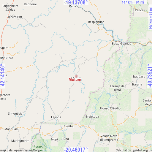
Mutum GPS coordinates[2]
19° 48' 0" South, 41° 26' 17.988" West
| Map corner | latitude | longitude |
|---|---|---|
| Upper-left | -19.13708°, | -42.14146° |
| Center: | -19.8°, | -41.43833° |
| Lower-right: | -20.46017°, | -40.73521° |
| Map W x H: | 147.1×147.1 km | = 91.4×91.4mi |
| max Lat: | 2.81972° ⇑55.8% North |
| Mutum: | -19.8° |
| min Lat: | ⇓44.2% South -33.69111° |
| min Long | Mutum | max Long |
| -72.89583° | -41.43833° | -32.41083° |
| W 68.5%⇐ | ⇒31.5% E |
Elevation
Elevation of Mutum is 223 m = 732 ft, and this is 157.9 m = 518 ft below average elevation for this country.
| Max E: |
1603 m = 5259 ft | 59.1% |
| Avg. | 380.9 m = 1250 ft | |
| Mutum | 223 m = 732 ft | |
Min E: |
0 m = 0 ft | 40.9% |
See also: Brazil elevation on elevation.city.
Geographical zone
Mutum is located in South Torrid zone (between Equator and Tropic of Capricorn). Distance of this Southern Tropic circle is 404.4 km =251.3 mi to South.| Distance of | km | miles | from Mutum |
|---|---|---|---|
| Equator | 2201.6 | 1368 | to North |
| Tropic Capricorn | 404.4 | 251.3 | to South |
| Antarctic Circle | 5199.6 | 3230.9 | to South |
| South Pole | 7805.5 | 4850.1 | to South |


Nearby cities:
15 places around Mutum: (largest is in red/bold)
• Afonso Cláudio
44.8 km =27.8 mi,  132°
132°
• Aimorés
51.8 km =32.2 mi,  49°
49°
• Baixo Guandu
54.2 km =33.7 mi, 54°
• Caratinga
73.3 km =45.5 mi,  270°
270°
• Conceição do Castelo
66.4 km =41.3 mi,  162°
162°
• Conselheiro Pena
69.9 km =43.4 mi,  357°
357°
• Ibatiba
48.8 km =30.3 mi,  188°
188°
• Irupi
64.2 km =39.9 mi,  199°
199°
• Itaguaçu
61 km =37.9 mi,  90°
90°
• Itarana
59.5 km =37 mi,  97°
97°
• Iúna
61.5 km =38.2 mi, 189°
• Lajinha
43.6 km =27.1 mi,  206°
206°
• Laranja da Terra
41.4 km =25.7 mi,  105°
105°
• Muniz Freire
73.9 km =45.9 mi,  177°
177°
• Resplendor
56.1 km =34.9 mi,  19°
19°
Sources, notices
• [Note1] Compared only with cities in Brazil existing in our database
• [Src1] Map data: © OpenStreetMap contributors (CC-BY-SA)
• [Src2] Other city data from geonames.org with taken over terms of usage.
• [Src3] Geographical zone / Annual Mean Temperature by Robert A. Rohde @ Wikipedia
