Ibiraçu geodata
Ibiraçu (Espírito Santo) is a populated place; located in Brazil in America/Sao_Paulo (GMT-3) time zone. With population of 8,921 people, there are 1720 cities with bigger population in this country. Compared to other cities in Brazil, 56.1% of cities are located further ↑North; 73.3% of cities are located further ←West and 77.7% of cities have higher elevation than Ibiraçu. Note1


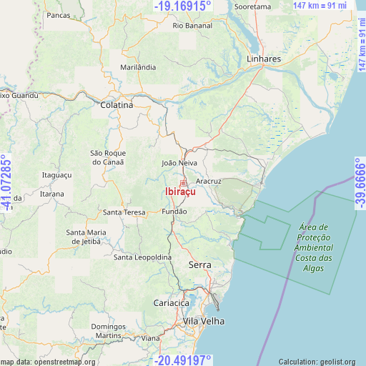
Ibiraçu GPS coordinates[2]
19° 49' 54.984" South, 40° 22' 10.992" West
| Map corner | latitude | longitude |
|---|---|---|
| Upper-left | -19.16915°, | -41.07285° |
| Center: | -19.83194°, | -40.36972° |
| Lower-right: | -20.49197°, | -39.6666° |
| Map W x H: | 147.1×147.1 km | = 91.4×91.4mi |
| max Lat: | 2.81972° ⇑56.1% North |
| Ibiraçu: | -19.83194° |
| min Lat: | ⇓43.9% South -33.69111° |
| min Long | Ibiraçu | max Long |
| -72.89583° | -40.36972° | -32.41083° |
| W 73.3%⇐ | ⇒26.7% E |
Elevation
Elevation of Ibiraçu is 58 m = 190 ft, and this is 322.9 m = 1059 ft below average elevation for this country.
| Max E: |
1603 m = 5259 ft | 77.7% |
| Avg. | 380.9 m = 1250 ft | |
| Ibiraçu | 58 m = 190 ft | |
Min E: |
0 m = 0 ft | 22.3% |
See also: Brazil elevation on elevation.city.
Geographical zone
Ibiraçu is located in South Torrid zone (between Equator and Tropic of Capricorn). Distance of this Southern Tropic circle is 400.8 km =249 mi to South.| Distance of | km | miles | from Ibiraçu |
|---|---|---|---|
| Equator | 2205.1 | 1370.2 | to North |
| Tropic Capricorn | 400.8 | 249 | to South |
| Antarctic Circle | 5196.1 | 3228.7 | to South |
| South Pole | 7802 | 4847.9 | to South |


Nearby cities:
15 places around Ibiraçu: (largest is in red/bold)
• Aracruz
10.2 km =6.3 mi,  82°
82°
• Colatina
42.5 km =26.4 mi,  319°
319°
• Fundão
11.9 km =7.4 mi,  197°
197°
• Itaguaçu
50.9 km =31.6 mi,  273°
273°
• Itarana
53.1 km =33 mi,  264°
264°
• Jetibá
38.8 km =24.1 mi,  237°
237°
• João Neiva
8.4 km =5.2 mi,  348°
348°
• Linhares
58.1 km =36.1 mi,  32°
32°
• Marilândia
50 km =31.1 mi,  338°
338°
• Santa Leopoldina
34.2 km =21.3 mi,  209°
209°
• Santa Maria de Jetibá
44.7 km =27.8 mi, 240°
• Santa Teresa
26.7 km =16.6 mi, 244°
• Serra
33.6 km =20.9 mi,  168°
168°
• Vila Velha
55.9 km =34.7 mi, 171°
• Vitória
54.3 km =33.7 mi,  176°
176°
Sources, notices
• [Note1] Compared only with cities in Brazil existing in our database
• [Src1] Map data: © OpenStreetMap contributors (CC-BY-SA)
• [Src2] Other city data from geonames.org with taken over terms of usage.
• [Src3] Geographical zone / Annual Mean Temperature by Robert A. Rohde @ Wikipedia
