Aracruz geodata
Aracruz (Espírito Santo) is a populated place; located in Brazil in America/Sao_Paulo (GMT-3) time zone. With population of 58,271 people, there are 377 cities with bigger population in this country. Compared to other cities in Brazil, 56% of cities are located further ↑North; 74.2% of cities are located further ←West and 75.7% of cities have higher elevation than Aracruz. Note1


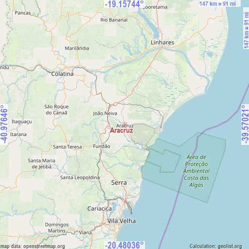
Aracruz GPS coordinates[2]
19° 49' 13.008" South, 40° 16' 23.988" West
| Map corner | latitude | longitude |
|---|---|---|
| Upper-left | -19.15744°, | -40.97646° |
| Center: | -19.82028°, | -40.27333° |
| Lower-right: | -20.48036°, | -39.57021° |
| Map W x H: | 147.1×147.1 km | = 91.4×91.4mi |
| max Lat: | 2.81972° ⇑56% North |
| Aracruz: | -19.82028° |
| min Lat: | ⇓44% South -33.69111° |
| min Long | Aracruz | max Long |
| -72.89583° | -40.27333° | -32.41083° |
| W 74.2%⇐ | ⇒25.8% E |
Elevation
Elevation of Aracruz is 73 m = 240 ft, and this is 307.9 m = 1010 ft below average elevation for this country.
| Max E: |
1603 m = 5259 ft | 75.7% |
| Avg. | 380.9 m = 1250 ft | |
| Aracruz | 73 m = 240 ft | |
Min E: |
0 m = 0 ft | 24.3% |
See also: Aracruz elevation on elevation.city.
Geographical zone
Aracruz is located in South Torrid zone (between Equator and Tropic of Capricorn). Distance of this Southern Tropic circle is 402.1 km =249.9 mi to South.| Distance of | km | miles | from Aracruz |
|---|---|---|---|
| Equator | 2203.8 | 1369.4 | to North |
| Tropic Capricorn | 402.1 | 249.9 | to South |
| Antarctic Circle | 5197.4 | 3229.5 | to South |
| South Pole | 7803.3 | 4848.7 | to South |


Nearby cities:
15 places around Aracruz: (largest is in red/bold)
• Colatina
48.7 km =30.3 mi,  309°
309°
• Fundão
18.7 km =11.6 mi,  227°
227°
• Ibiraçu
10.2 km =6.3 mi,  262°
262°
• Itaguaçu
60.9 km =37.8 mi,  271°
271°
• Jetibá
48.1 km =29.9 mi,  242°
242°
• João Neiva
13.7 km =8.5 mi,  300°
300°
• Linhares
52.2 km =32.4 mi,  23°
23°
• Marilândia
53.3 km =33.1 mi,  328°
328°
• Rio Bananal
62.1 km =38.6 mi,  354°
354°
• Santa Leopoldina
41.1 km =25.5 mi,  220°
220°
• Santa Maria de Jetibá
54.3 km =33.7 mi, 244°
• Santa Teresa
36.5 km =22.7 mi,  249°
249°
• Serra
34.5 km =21.4 mi,  185°
185°
• Vila Velha
56.7 km =35.2 mi,  182°
182°
• Vitória
55.9 km =34.7 mi, 186°
Sources, notices
• [Note1] Compared only with cities in Brazil existing in our database
• [Src1] Map data: © OpenStreetMap contributors (CC-BY-SA)
• [Src2] Other city data from geonames.org with taken over terms of usage.
• [Src3] Geographical zone / Annual Mean Temperature by Robert A. Rohde @ Wikipedia
