Irará geodata
Irará (Bahia) is a populated place; located in Brazil in America/Bahia (GMT-3) time zone. With population of 9,099 people, there are 1711 cities with bigger population in this country. Compared to other cities in Brazil, 62.3% of cities are located further ↓South; 81.4% of cities are located further ←West and 54.6% of cities have higher elevation than Irará. Note1


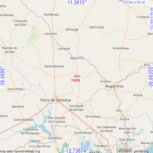
Irará GPS coordinates[2]
12° 3' 0" South, 38° 46' 0.012" West
| Map corner | latitude | longitude |
|---|---|---|
| Upper-left | -11.3615°, | -39.4698° |
| Center: | -12.05°, | -38.76667° |
| Lower-right: | -12.73674°, | -38.06355° |
| Map W x H: | 152.9×152.9 km | = 95×95mi |
| max Lat: | 2.81972° ⇑37.7% North |
| Irará: | -12.05° |
| min Lat: | ⇓62.3% South -33.69111° |
| min Long | Irará | max Long |
| -72.89583° | -38.76667° | -32.41083° |
| W 81.4%⇐ | ⇒18.6% E |
Elevation
Elevation of Irará is 274 m = 899 ft, and this is 106.9 m = 351 ft below average elevation for this country.
| Max E: |
1603 m = 5259 ft | 54.6% |
| Avg. | 380.9 m = 1250 ft | |
| Irará | 274 m = 899 ft | |
Min E: |
0 m = 0 ft | 45.4% |
See also: Brazil elevation on elevation.city.
Geographical zone
Irará is located in South Torrid zone (between Equator and Tropic of Capricorn). Distance of this Southern Tropic circle is 1266.1 km =786.7 mi to South.| Distance of | km | miles | from Irará |
|---|---|---|---|
| Equator | 1339.8 | 832.5 | to North |
| Tropic Capricorn | 1266.1 | 786.7 | to South |
| Antarctic Circle | 6061.3 | 3766.3 | to South |
| South Pole | 8667.2 | 5385.5 | to South |


Nearby cities:
15 places around Irará: (largest is in red/bold)
• Alagoinhas
39 km =24.2 mi,  104°
104°
• Anguera
53.4 km =33.2 mi,  257°
257°
• Cachoeira
65 km =40.4 mi,  199°
199°
• Catu
54 km =33.6 mi,  128°
128°
• Conceição da Feira
56.6 km =35.2 mi,  206°
206°
• Conceição do Jacuípe
29.7 km =18.5 mi,  180°
180°
• Coração de Maria
20.5 km =12.7 mi,  174°
174°
• Feira de Santana
32.4 km =20.1 mi,  222°
222°
• Inhambupe
53.8 km =33.4 mi,  56°
56°
• Santo Amaro
55.5 km =34.5 mi, 173°
• Santo Estêvão
67.5 km =41.9 mi,  231°
231°
• Serrinha
50.3 km =31.3 mi,  328°
328°
• São Francisco do Conde
64.9 km =40.3 mi, 171°
• São Gonçalo dos Campos
47.8 km =29.7 mi, 207°
• São Sebastião do Passé
59.3 km =36.8 mi,  150°
150°
Sources, notices
• [Note1] Compared only with cities in Brazil existing in our database
• [Src1] Map data: © OpenStreetMap contributors (CC-BY-SA)
• [Src2] Other city data from geonames.org with taken over terms of usage.
• [Src3] Geographical zone / Annual Mean Temperature by Robert A. Rohde @ Wikipedia
