Ibaiti geodata
Ibaiti (Paraná) is a populated place; located in Brazil in America/Sao_Paulo (GMT-3) time zone. With population of 25,796 people, there are 763 cities with bigger population in this country. Compared to other cities in Brazil, 85.3% of cities are located further ↑North; 79.2% of cities are located further →East and 91.9% of cities have lower elevation than Ibaiti. Note1


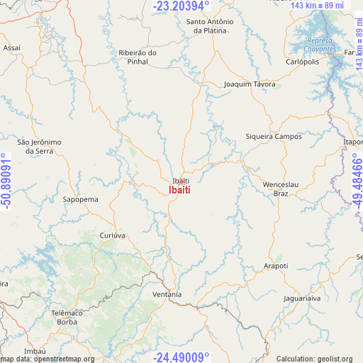
Ibaiti GPS coordinates[2]
23° 50' 54.996" South, 50° 11' 16.008" West
| Map corner | latitude | longitude |
|---|---|---|
| Upper-left | -23.20394°, | -50.89091° |
| Center: | -23.84861°, | -50.18778° |
| Lower-right: | -24.49009°, | -49.48466° |
| Map W x H: | 143×143 km | = 88.9×88.9mi |
| max Lat: | 2.81972° ⇑85.3% North |
| Ibaiti: | -23.84861° |
| min Lat: | ⇓14.7% South -33.69111° |
| min Long | Ibaiti | max Long |
| -72.89583° | -50.18778° | -32.41083° |
| W 20.8%⇐ | ⇒79.2% E |
Elevation
Elevation of Ibaiti is 842 m = 2762 ft, and this is 461.1 m = 1513 ft above average elevation for this country.
| Max E: |
1603 m = 5259 ft | 8.1% |
| Ibaiti | 842 m 2762 ft | |
| Avg. | 380.9 m = 1250 ft | |
Min E: |
0 m = 0 ft | 91.9% |
See also: Brazil elevation on elevation.city.
Geographical zone
Ibaiti is located in South temperate zone (between Tropic of Capricorn and the Antarctic Circle). Distance of this Southern Tropic circle is 45.8 km =28.5 mi to North.| Distance of | km | miles | from Ibaiti |
|---|---|---|---|
| Equator | 2651.7 | 1647.7 | to North |
| Tropic Capricorn | 45.8 | 28.5 | to North |
| Antarctic Circle | 4749.5 | 2951.2 | to South |
| South Pole | 7355.3 | 4570.4 | to South |


Nearby cities:
15 places around Ibaiti: (largest is in red/bold)
• Assaí
85 km =52.8 mi,  308°
308°
• Bandeirantes
84.1 km =52.3 mi,  347°
347°
• Fartura
85.9 km =53.4 mi,  53°
53°
• Itaporanga
72.7 km =45.2 mi,  77°
77°
• Jacarezinho
79.7 km =49.5 mi,  16°
16°
• Jaguariaíva
65.5 km =40.7 mi,  132°
132°
• Ortigueira
87.1 km =54.1 mi,  242°
242°
• Piraí do Sul
79.1 km =49.2 mi,  162°
162°
• Santo Antônio da Platina
62.6 km =38.9 mi,  10°
10°
• Sengés
79.3 km =49.3 mi,  111°
111°
• Siqueira Campos
40.2 km =25 mi,  63°
63°
• Telêmaco Borba
68.4 km =42.5 mi,  219°
219°
• Terra Roxa
15.9 km =9.9 mi,  92°
92°
• Tibagi
77 km =47.8 mi,  197°
197°
• Wenceslau Braz
39.2 km =24.4 mi, 94°
Sources, notices
• [Note1] Compared only with cities in Brazil existing in our database
• [Src1] Map data: © OpenStreetMap contributors (CC-BY-SA)
• [Src2] Other city data from geonames.org with taken over terms of usage.
• [Src3] Geographical zone / Annual Mean Temperature by Robert A. Rohde @ Wikipedia
