Sengés geodata
Sengés (Paraná) is a populated place; located in Brazil in America/Sao_Paulo (GMT-3) time zone. With population of 14,867 people, there are 1220 cities with bigger population in this country. Compared to other cities in Brazil, 86.4% of cities are located further ↑North; 75.3% of cities are located further →East and 72.9% of cities have lower elevation than Sengés. Note1


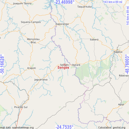
Sengés GPS coordinates[2]
24° 6' 48.06" South, 49° 27' 47.34" West
| Map corner | latitude | longitude |
|---|---|---|
| Upper-left | -23.46998°, | -50.16628° |
| Center: | -24.11335°, | -49.46315° |
| Lower-right: | -24.7535°, | -48.76003° |
| Map W x H: | 142.7×142.7 km | = 88.7×88.7mi |
| max Lat: | 2.81972° ⇑86.4% North |
| Sengés: | -24.11335° |
| min Lat: | ⇓13.6% South -33.69111° |
| min Long | Sengés | max Long |
| -72.89583° | -49.46315° | -32.41083° |
| W 24.7%⇐ | ⇒75.3% E |
Elevation
Elevation of Sengés is 602 m = 1975 ft, and this is 221.1 m = 725 ft above average elevation for this country.
| Max E: |
1603 m = 5259 ft | 27.1% |
| Sengés | 602 m 1975 ft | |
| Avg. | 380.9 m = 1250 ft | |
Min E: |
0 m = 0 ft | 72.9% |
See also: Brazil elevation on elevation.city.
Geographical zone
Sengés is located in South temperate zone (between Tropic of Capricorn and the Antarctic Circle). Distance of this Southern Tropic circle is 75.2 km =46.7 mi to North.| Distance of | km | miles | from Sengés |
|---|---|---|---|
| Equator | 2681.2 | 1666 | to North |
| Tropic Capricorn | 75.2 | 46.7 | to North |
| Antarctic Circle | 4720 | 2932.9 | to South |
| South Pole | 7325.9 | 4552.1 | to South |


Nearby cities:
15 places around Sengés: (largest is in red/bold)
• Apiaí
76.8 km =47.7 mi,  125°
125°
• Fartura
80.8 km =50.2 mi,  356°
356°
• Ibaiti
79.3 km =49.3 mi,  291°
291°
• Itaberá
43.3 km =26.9 mi,  49°
49°
• Itapeva
61.4 km =38.2 mi,  76°
76°
• Itaporanga
45.2 km =28.1 mi, 356°
• Itararé
13.3 km =8.3 mi,  89°
89°
• Itaí
86.1 km =53.5 mi,  26°
26°
• Jaguariaíva
28.9 km =18 mi,  239°
239°
• Piraí do Sul
67.3 km =41.8 mi,  226°
226°
• Ribeirão Branco
71.8 km =44.6 mi,  99°
99°
• Siqueira Campos
60.4 km =37.5 mi,  321°
321°
• Taquarituba
68.2 km =42.4 mi,  19°
19°
• Terra Roxa
64.4 km =40 mi,  296°
296°
• Wenceslau Braz
43.6 km =27.1 mi,  307°
307°
Sources, notices
• [Note1] Compared only with cities in Brazil existing in our database
• [Src1] Map data: © OpenStreetMap contributors (CC-BY-SA)
• [Src2] Other city data from geonames.org with taken over terms of usage.
• [Src3] Geographical zone / Annual Mean Temperature by Robert A. Rohde @ Wikipedia
