Fartura geodata
Fartura (São Paulo) is a populated place; located in Brazil in America/Sao_Paulo (GMT-3) time zone. With population of 12,405 people, there are 1435 cities with bigger population in this country. Compared to other cities in Brazil, 81.7% of cities are located further ↑North; 75.8% of cities are located further →East and 62.9% of cities have lower elevation than Fartura. Note1


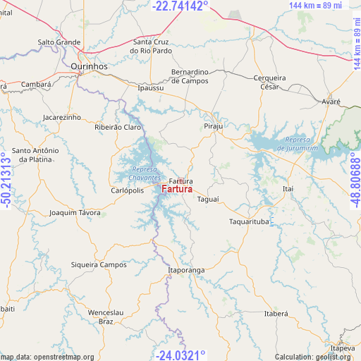
Fartura GPS coordinates[2]
23° 23' 17.988" South, 49° 30' 36" West
| Map corner | latitude | longitude |
|---|---|---|
| Upper-left | -22.74142°, | -50.21313° |
| Center: | -23.38833°, | -49.51° |
| Lower-right: | -24.0321°, | -48.80688° |
| Map W x H: | 143.5×143.5 km | = 89.2×89.2mi |
| max Lat: | 2.81972° ⇑81.7% North |
| Fartura: | -23.38833° |
| min Lat: | ⇓18.3% South -33.69111° |
| min Long | Fartura | max Long |
| -72.89583° | -49.51° | -32.41083° |
| W 24.2%⇐ | ⇒75.8% E |
Elevation
Elevation of Fartura is 508 m = 1667 ft, and this is 127.1 m = 417 ft above average elevation for this country.
| Max E: |
1603 m = 5259 ft | 37.1% |
| Fartura | 508 m 1667 ft | |
| Avg. | 380.9 m = 1250 ft | |
Min E: |
0 m = 0 ft | 62.9% |
See also: Brazil elevation on elevation.city.
Geographical zone
Fartura is located in South Torrid zone (between Equator and Tropic of Capricorn). Distance of this Southern Tropic circle is 5.4 km =3.4 mi to South.| Distance of | km | miles | from Fartura |
|---|---|---|---|
| Equator | 2600.5 | 1615.9 | to North |
| Tropic Capricorn | 5.4 | 3.4 | to South |
| Antarctic Circle | 4800.6 | 2983 | to South |
| South Pole | 7406.5 | 4602.2 | to South |


Nearby cities:
15 places around Fartura: (largest is in red/bold)
• Bernardino de Campos
41.9 km =26 mi,  5°
5°
• Cerqueira César
52.7 km =32.7 mi,  41°
41°
• Chavantes
43.9 km =27.3 mi,  332°
332°
• Ipauçu
38.7 km =24 mi,  342°
342°
• Itaberá
64.9 km =40.3 mi,  144°
144°
• Itaporanga
35.6 km =22.1 mi,  176°
176°
• Itaí
42.9 km =26.7 mi,  94°
94°
• Jacarezinho
53.3 km =33.1 mi,  298°
298°
• Ourinhos
58.6 km =36.4 mi,  321°
321°
• Piraju
25.2 km =15.7 mi,  30°
30°
• Santa Cruz do Rio Pardo
55.8 km =34.7 mi,  347°
347°
• Santo Antônio da Platina
58.8 km =36.5 mi,  280°
280°
• Siqueira Campos
47 km =29.2 mi,  224°
224°
• Taquarituba
31.5 km =19.6 mi,  120°
120°
• Wenceslau Braz
61.7 km =38.3 mi,  208°
208°
Sources, notices
• [Note1] Compared only with cities in Brazil existing in our database
• [Src1] Map data: © OpenStreetMap contributors (CC-BY-SA)
• [Src2] Other city data from geonames.org with taken over terms of usage.
• [Src3] Geographical zone / Annual Mean Temperature by Robert A. Rohde @ Wikipedia
