Itaporanga geodata
Itaporanga (São Paulo) is a populated place; located in Brazil in America/Sao_Paulo (GMT-3) time zone. With population of 10,202 people, there are 1634 cities with bigger population in this country. Compared to other cities in Brazil, 84.5% of cities are located further ↑North; 75.5% of cities are located further →East and 70.6% of cities have lower elevation than Itaporanga. Note1


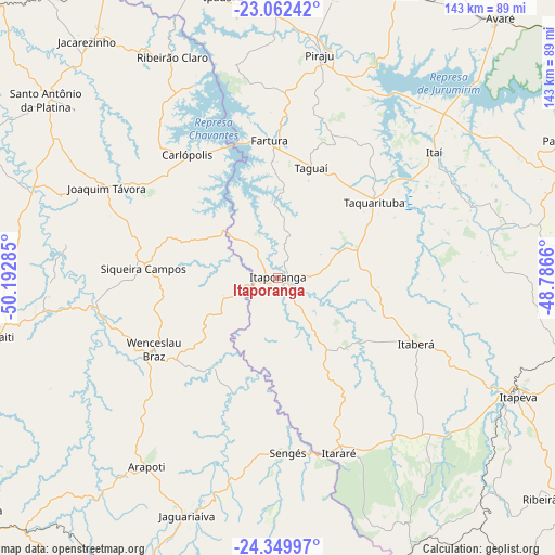
Itaporanga GPS coordinates[2]
23° 42' 28.008" South, 49° 29' 22.992" West
| Map corner | latitude | longitude |
|---|---|---|
| Upper-left | -23.06242°, | -50.19285° |
| Center: | -23.70778°, | -49.48972° |
| Lower-right: | -24.34997°, | -48.7866° |
| Map W x H: | 143.2×143.2 km | = 89×89mi |
| max Lat: | 2.81972° ⇑84.5% North |
| Itaporanga: | -23.70778° |
| min Lat: | ⇓15.5% South -33.69111° |
| min Long | Itaporanga | max Long |
| -72.89583° | -49.48972° | -32.41083° |
| W 24.5%⇐ | ⇒75.5% E |
Elevation
Elevation of Itaporanga is 580 m = 1903 ft, and this is 199.1 m = 653 ft above average elevation for this country.
| Max E: |
1603 m = 5259 ft | 29.4% |
| Itaporanga | 580 m 1903 ft | |
| Avg. | 380.9 m = 1250 ft | |
Min E: |
0 m = 0 ft | 70.6% |
See also: Brazil elevation on elevation.city.
Geographical zone
Itaporanga is located in South temperate zone (between Tropic of Capricorn and the Antarctic Circle). Distance of this Southern Tropic circle is 30.1 km =18.7 mi to North.| Distance of | km | miles | from Itaporanga |
|---|---|---|---|
| Equator | 2636.1 | 1638 | to North |
| Tropic Capricorn | 30.1 | 18.7 | to North |
| Antarctic Circle | 4765.1 | 2960.9 | to South |
| South Pole | 7371 | 4580.1 | to South |


Nearby cities:
15 places around Itaporanga: (largest is in red/bold)
• Fartura
35.6 km =22.1 mi,  356°
356°
• Ibaiti
72.7 km =45.2 mi,  257°
257°
• Ipauçu
73.7 km =45.8 mi,  349°
349°
• Itaberá
39.8 km =24.7 mi,  115°
115°
• Itapeva
69.5 km =43.2 mi, 116°
• Itararé
47.8 km =29.7 mi,  160°
160°
• Itaí
51.9 km =32.2 mi,  51°
51°
• Jaguariaíva
63.7 km =39.6 mi,  200°
200°
• Piraju
58.2 km =36.2 mi,  10°
10°
• Santo Antônio da Platina
75.5 km =46.9 mi,  307°
307°
• Sengés
45.2 km =28.1 mi,  176°
176°
• Siqueira Campos
35.1 km =21.8 mi,  273°
273°
• Taquarituba
31.7 km =19.7 mi, 52°
• Terra Roxa
57.5 km =35.7 mi,  253°
253°
• Wenceslau Braz
36.8 km =22.9 mi,  239°
239°
Sources, notices
• [Note1] Compared only with cities in Brazil existing in our database
• [Src1] Map data: © OpenStreetMap contributors (CC-BY-SA)
• [Src2] Other city data from geonames.org with taken over terms of usage.
• [Src3] Geographical zone / Annual Mean Temperature by Robert A. Rohde @ Wikipedia
