Guarujá geodata
Guarujá (São Paulo) is a seat of a second-order administrative division; located in Brazil in America/Sao_Paulo (GMT-3) time zone. With population of 310,424 people, there are 70 cities with bigger population in this country. Compared to other cities in Brazil, 85.9% of cities are located further ↑North; 53.5% of cities are located further →East and 92.4% of cities have higher elevation than Guarujá. Note1


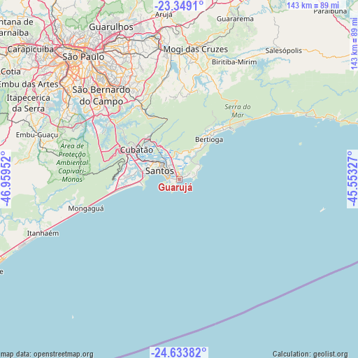
Guarujá GPS coordinates[2]
23° 59' 35.016" South, 46° 15' 23.004" West
| Map corner | latitude | longitude |
|---|---|---|
| Upper-left | -23.3491°, | -46.95952° |
| Center: | -23.99306°, | -46.25639° |
| Lower-right: | -24.63382°, | -45.55327° |
| Map W x H: | 142.8×142.8 km | = 88.7×88.7mi |
| max Lat: | 2.81972° ⇑85.9% North |
| Guarujá: | -23.99306° |
| min Lat: | ⇓14.1% South -33.69111° |
| min Long | Guarujá | max Long |
| -72.89583° | -46.25639° | -32.41083° |
| W 46.5%⇐ | ⇒53.5% E |
Elevation
Elevation of Guarujá is 13 m = 43 ft, and this is 367.9 m = 1207 ft below average elevation for this country.
| Max E: |
1603 m = 5259 ft | 92.4% |
| Avg. | 380.9 m = 1250 ft | |
| Guarujá | 13 m = 43 ft | |
Min E: |
0 m = 0 ft | 7.6% |
See also: Guarujá elevation on elevation.city.
Geographical zone
Guarujá is located in South temperate zone (between Tropic of Capricorn and the Antarctic Circle). Distance of this Southern Tropic circle is 61.9 km =38.5 mi to North.| Distance of | km | miles | from Guarujá |
|---|---|---|---|
| Equator | 2667.8 | 1657.7 | to North |
| Tropic Capricorn | 61.9 | 38.5 | to North |
| Antarctic Circle | 4733.4 | 2941.2 | to South |
| South Pole | 7339.3 | 4560.4 | to South |


Nearby cities:
15 places around Guarujá: (largest is in red/bold)
• Bertioga
19.5 km =12.1 mi,  37°
37°
• Cubatão
20.3 km =12.6 mi,  302°
302°
• Diadema
50.5 km =31.4 mi,  312°
312°
• Ferraz de Vasconcelos
51.6 km =32.1 mi,  347°
347°
• Mauá
41.7 km =25.9 mi,  330°
330°
• Mongaguá
38.6 km =24 mi,  253°
253°
• Praia Grande
14.9 km =9.3 mi,  264°
264°
• Ribeirão Pires
35.2 km =21.9 mi, 333°
• Rio Grande da Serra
31.2 km =19.4 mi, 332°
• Santo André
46.5 km =28.9 mi,  321°
321°
• Santos
8.6 km =5.3 mi,  294°
294°
• Suzano
50.4 km =31.3 mi, 353°
• São Bernardo do Campo
45.7 km =28.4 mi, 316°
• São Caetano do Sul
50.9 km =31.6 mi, 323°
• São Vicente
14.2 km =8.8 mi,  283°
283°
Sources, notices
• [Note1] Compared only with cities in Brazil existing in our database
• [Src1] Map data: © OpenStreetMap contributors (CC-BY-SA)
• [Src2] Other city data from geonames.org with taken over terms of usage.
• [Src3] Geographical zone / Annual Mean Temperature by Robert A. Rohde @ Wikipedia
