Perdões geodata
Perdões (Minas Gerais) is a populated place; located in Brazil in America/Sao_Paulo (GMT-3) time zone. With population of 17,821 people, there are 1051 cities with bigger population in this country. Compared to other cities in Brazil, 63.7% of cities are located further ↑North; 50.9% of cities are located further ←West and 91.9% of cities have lower elevation than Perdões. Note1


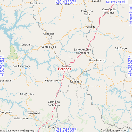
Perdões GPS coordinates[2]
21° 5' 26.988" South, 45° 5' 29.004" West
| Map corner | latitude | longitude |
|---|---|---|
| Upper-left | -20.43337°, | -45.79452° |
| Center: | -21.09083°, | -45.09139° |
| Lower-right: | -21.74539°, | -44.38827° |
| Map W x H: | 145.9×145.9 km | = 90.7×90.7mi |
| max Lat: | 2.81972° ⇑63.7% North |
| Perdões: | -21.09083° |
| min Lat: | ⇓36.3% South -33.69111° |
| min Long | Perdões | max Long |
| -72.89583° | -45.09139° | -32.41083° |
| W 50.9%⇐ | ⇒49.1% E |
Elevation
Elevation of Perdões is 842 m = 2762 ft, and this is 461.1 m = 1513 ft above average elevation for this country.
| Max E: |
1603 m = 5259 ft | 8.1% |
| Perdões | 842 m 2762 ft | |
| Avg. | 380.9 m = 1250 ft | |
Min E: |
0 m = 0 ft | 91.9% |
See also: Brazil elevation on elevation.city.
Geographical zone
Perdões is located in South Torrid zone (between Equator and Tropic of Capricorn). Distance of this Southern Tropic circle is 260.8 km =162.1 mi to South.| Distance of | km | miles | from Perdões |
|---|---|---|---|
| Equator | 2345.1 | 1457.2 | to North |
| Tropic Capricorn | 260.8 | 162.1 | to South |
| Antarctic Circle | 5056.1 | 3141.7 | to South |
| South Pole | 7662 | 4760.9 | to South |


Nearby cities:
15 places around Perdões: (largest is in red/bold)
• Boa Esperança
49.2 km =30.6 mi,  270°
270°
• Bom Sucesso
35.2 km =21.9 mi,  79°
79°
• Campo Belo
28.9 km =18 mi,  318°
318°
• Campos Gerais
71 km =44.1 mi,  256°
256°
• Cláudio
79.6 km =49.5 mi,  25°
25°
• Elói Mendes
75.8 km =47.1 mi,  220°
220°
• Formiga
77.9 km =48.4 mi,  333°
333°
• Itapecerica
68.8 km =42.8 mi,  357°
357°
• Lavras
19.6 km =12.2 mi,  151°
151°
• Nepomuceno
21.7 km =13.5 mi, 223°
• Oliveira
51.7 km =32.1 mi, 32°
• Santo Antônio do Amparo
24.1 km =15 mi,  48°
48°
• Três Corações
69.4 km =43.1 mi,  193°
193°
• Três Pontas
53.3 km =33.1 mi,  234°
234°
• Varginha
62.1 km =38.6 mi,  214°
214°
Sources, notices
• [Note1] Compared only with cities in Brazil existing in our database
• [Src1] Map data: © OpenStreetMap contributors (CC-BY-SA)
• [Src2] Other city data from geonames.org with taken over terms of usage.
• [Src3] Geographical zone / Annual Mean Temperature by Robert A. Rohde @ Wikipedia
