Campo Belo geodata
Campo Belo (Minas Gerais) is a populated place; located in Brazil in America/Sao_Paulo (GMT-3) time zone. With population of 47,491 people, there are 456 cities with bigger population in this country. Compared to other cities in Brazil, 62.4% of cities are located further ↑North; 50.1% of cities are located further →East and 92.7% of cities have lower elevation than Campo Belo. Note1


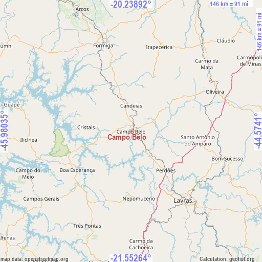
Campo Belo GPS coordinates[2]
20° 53' 49.992" South, 45° 16' 37.992" West
| Map corner | latitude | longitude |
|---|---|---|
| Upper-left | -20.23892°, | -45.98035° |
| Center: | -20.89722°, | -45.27722° |
| Lower-right: | -21.55264°, | -44.5741° |
| Map W x H: | 146.1×146.1 km | = 90.8×90.8mi |
| max Lat: | 2.81972° ⇑62.4% North |
| Campo Belo: | -20.89722° |
| min Lat: | ⇓37.6% South -33.69111° |
| min Long | Campo Belo | max Long |
| -72.89583° | -45.27722° | -32.41083° |
| W 49.9%⇐ | ⇒50.1% E |
Elevation
Elevation of Campo Belo is 854 m = 2802 ft, and this is 473.1 m = 1552 ft above average elevation for this country.
| Max E: |
1603 m = 5259 ft | 7.3% |
| Campo Belo | 854 m 2802 ft | |
| Avg. | 380.9 m = 1250 ft | |
Min E: |
0 m = 0 ft | 92.7% |
See also: Campo Belo elevation on elevation.city.
Geographical zone
Campo Belo is located in South Torrid zone (between Equator and Tropic of Capricorn). Distance of this Southern Tropic circle is 282.4 km =175.5 mi to South.| Distance of | km | miles | from Campo Belo |
|---|---|---|---|
| Equator | 2323.6 | 1443.8 | to North |
| Tropic Capricorn | 282.4 | 175.5 | to South |
| Antarctic Circle | 5077.6 | 3155.1 | to South |
| South Pole | 7683.5 | 4774.3 | to South |


Nearby cities:
15 places around Campo Belo: (largest is in red/bold)
• Arcos
73.7 km =45.8 mi,  338°
338°
• Boa Esperança
36.8 km =22.9 mi,  234°
234°
• Bom Sucesso
56 km =34.8 mi,  105°
105°
• Campos Gerais
62.5 km =38.8 mi, 233°
• Cláudio
73.3 km =45.5 mi,  46°
46°
• Elói Mendes
84.7 km =52.6 mi,  200°
200°
• Formiga
50.6 km =31.4 mi, 342°
• Itapecerica
49.8 km =30.9 mi,  18°
18°
• Lavras
48.2 km =30 mi,  143°
143°
• Nepomuceno
37.6 km =23.4 mi,  173°
173°
• Oliveira
51.8 km =32.2 mi,  64°
64°
• Perdões
28.9 km =18 mi, 138°
• Santo Antônio do Amparo
37.6 km =23.4 mi,  98°
98°
• Três Pontas
57.6 km =35.8 mi,  205°
205°
• Varginha
74.4 km =46.2 mi,  192°
192°
Sources, notices
• [Note1] Compared only with cities in Brazil existing in our database
• [Src1] Map data: © OpenStreetMap contributors (CC-BY-SA)
• [Src2] Other city data from geonames.org with taken over terms of usage.
• [Src3] Geographical zone / Annual Mean Temperature by Robert A. Rohde @ Wikipedia
