Oliveira geodata
Oliveira (Minas Gerais) is a populated place; located in Brazil in America/Sao_Paulo (GMT-3) time zone. With population of 34,710 people, there are 590 cities with bigger population in this country. Compared to other cities in Brazil, 61.1% of cities are located further ↑North; 52.2% of cities are located further ←West and 98% of cities have lower elevation than Oliveira. Note1


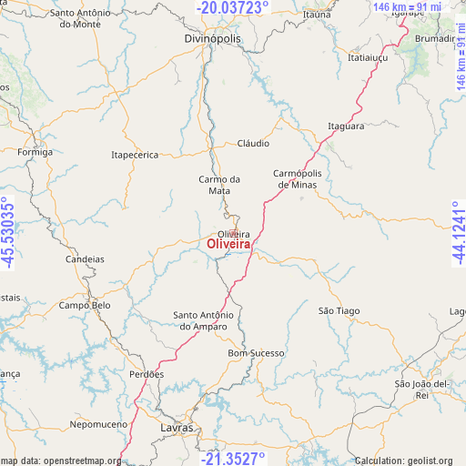
Oliveira GPS coordinates[2]
20° 41' 47.004" South, 44° 49' 37.992" West
| Map corner | latitude | longitude |
|---|---|---|
| Upper-left | -20.03723°, | -45.53035° |
| Center: | -20.69639°, | -44.82722° |
| Lower-right: | -21.3527°, | -44.1241° |
| Map W x H: | 146.3×146.3 km | = 90.9×90.9mi |
| max Lat: | 2.81972° ⇑61.1% North |
| Oliveira: | -20.69639° |
| min Lat: | ⇓38.9% South -33.69111° |
| min Long | Oliveira | max Long |
| -72.89583° | -44.82722° | -32.41083° |
| W 52.2%⇐ | ⇒47.8% E |
Elevation
Elevation of Oliveira is 985 m = 3232 ft, and this is 604.1 m = 1982 ft above average elevation for this country.
| Max E: |
1603 m = 5259 ft | 2% |
| Oliveira | 985 m 3232 ft | |
| Avg. | 380.9 m = 1250 ft | |
Min E: |
0 m = 0 ft | 98% |
See also: Brazil elevation on elevation.city.
Geographical zone
Oliveira is located in South Torrid zone (between Equator and Tropic of Capricorn). Distance of this Southern Tropic circle is 304.7 km =189.3 mi to South.| Distance of | km | miles | from Oliveira |
|---|---|---|---|
| Equator | 2301.2 | 1429.9 | to North |
| Tropic Capricorn | 304.7 | 189.3 | to South |
| Antarctic Circle | 5100 | 3169 | to South |
| South Pole | 7705.8 | 4788.2 | to South |


Nearby cities:
15 places around Oliveira: (largest is in red/bold)
• Bom Sucesso
38.1 km =23.7 mi,  169°
169°
• Campo Belo
51.8 km =32.2 mi,  244°
244°
• Carmo do Cajuru
57.3 km =35.6 mi,  5°
5°
• Cláudio
28.9 km =18 mi, 12°
• Divinópolis
61.8 km =38.4 mi,  353°
353°
• Formiga
67.5 km =41.9 mi,  292°
292°
• Itapecerica
39.8 km =24.7 mi,  308°
308°
• Itaúna
73.8 km =45.9 mi,  20°
20°
• Lavras
63.6 km =39.5 mi,  196°
196°
• Nepomuceno
73.2 km =45.5 mi,  215°
215°
• Perdões
51.7 km =32.1 mi,  212°
212°
• Santo Antônio do Amparo
29.4 km =18.3 mi, 198°
• Santo Antônio do Monte
83.4 km =51.8 mi,  324°
324°
• São João del Rei
76.4 km =47.5 mi,  129°
129°
• Tiradentes
81.6 km =50.7 mi,  124°
124°
Sources, notices
• [Note1] Compared only with cities in Brazil existing in our database
• [Src1] Map data: © OpenStreetMap contributors (CC-BY-SA)
• [Src2] Other city data from geonames.org with taken over terms of usage.
• [Src3] Geographical zone / Annual Mean Temperature by Robert A. Rohde @ Wikipedia
