Entre Rios geodata
Entre Rios (Bahia) is a populated place; located in Brazil in America/Bahia (GMT-3) time zone. With population of 27,405 people, there are 721 cities with bigger population in this country. Compared to other cities in Brazil, 62.4% of cities are located further ↓South; 84.1% of cities are located further ←West and 65.3% of cities have higher elevation than Entre Rios. Note1


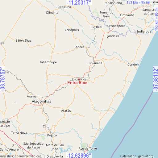
Entre Rios GPS coordinates[2]
11° 56' 30.984" South, 38° 5' 3.984" West
| Map corner | latitude | longitude |
|---|---|---|
| Upper-left | -11.25317°, | -38.78757° |
| Center: | -11.94194°, | -38.08444° |
| Lower-right: | -12.62896°, | -37.38132° |
| Map W x H: | 153×153 km | = 95.1×95.1mi |
| max Lat: | 2.81972° ⇑37.6% North |
| Entre Rios: | -11.94194° |
| min Lat: | ⇓62.4% South -33.69111° |
| min Long | Entre Rios | max Long |
| -72.89583° | -38.08444° | -32.41083° |
| W 84.1%⇐ | ⇒15.9% E |
Elevation
Elevation of Entre Rios is 165 m = 541 ft, and this is 215.9 m = 708 ft below average elevation for this country.
| Max E: |
1603 m = 5259 ft | 65.3% |
| Avg. | 380.9 m = 1250 ft | |
| Entre Rios | 165 m = 541 ft | |
Min E: |
0 m = 0 ft | 34.7% |
See also: Brazil elevation on elevation.city.
Geographical zone
Entre Rios is located in South Torrid zone (between Equator and Tropic of Capricorn). Distance of this Southern Tropic circle is 1278.1 km =794.2 mi to South.| Distance of | km | miles | from Entre Rios |
|---|---|---|---|
| Equator | 1327.8 | 825.1 | to North |
| Tropic Capricorn | 1278.1 | 794.2 | to South |
| Antarctic Circle | 6073.4 | 3773.8 | to South |
| South Pole | 8679.2 | 5393 | to South |


Nearby cities:
15 places around Entre Rios: (largest is in red/bold)
• Acajutiba
32 km =19.9 mi,  13°
13°
• Alagoinhas
42.3 km =26.3 mi,  239°
239°
• Catu
55.8 km =34.7 mi,  214°
214°
• Conde
53.5 km =33.2 mi,  74°
74°
• Cristinápolis
63 km =39.1 mi,  34°
34°
• Esplanada
22.2 km =13.8 mi,  43°
43°
• Inhambupe
34.1 km =21.2 mi,  300°
300°
• Irará
75.2 km =46.7 mi,  260°
260°
• Itapicuru
71.4 km =44.4 mi,  346°
346°
• Mata de São João
69.5 km =43.2 mi,  199°
199°
• Olindina
69.5 km =43.2 mi,  337°
337°
• Praia do Baixio
46.2 km =28.7 mi,  113°
113°
• Rio Real
53.5 km =33.2 mi,  17°
17°
• Tomar do Geru
68.6 km =42.6 mi, 22°
• Umbaúba
77.6 km =48.2 mi, 36°
Sources, notices
• [Note1] Compared only with cities in Brazil existing in our database
• [Src1] Map data: © OpenStreetMap contributors (CC-BY-SA)
• [Src2] Other city data from geonames.org with taken over terms of usage.
• [Src3] Geographical zone / Annual Mean Temperature by Robert A. Rohde @ Wikipedia
