Elói Mendes geodata
Elói Mendes (Minas Gerais) is a populated place; located in Brazil in America/Sao_Paulo (GMT-3) time zone. With population of 19,413 people, there are 967 cities with bigger population in this country. Compared to other cities in Brazil, 67.3% of cities are located further ↑North; 51.3% of cities are located further →East and 95.6% of cities have lower elevation than Elói Mendes. Note1


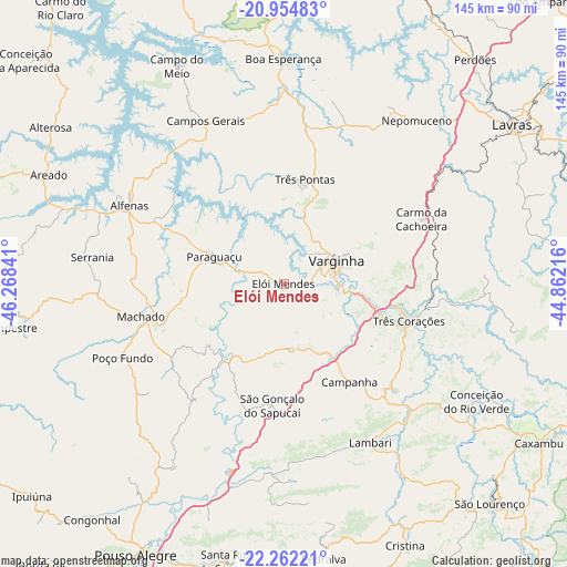
Elói Mendes GPS coordinates[2]
21° 36' 36" South, 45° 33' 55.008" West
| Map corner | latitude | longitude |
|---|---|---|
| Upper-left | -20.95483°, | -46.26841° |
| Center: | -21.61°, | -45.56528° |
| Lower-right: | -22.26221°, | -44.86216° |
| Map W x H: | 145.4×145.4 km | = 90.3×90.3mi |
| max Lat: | 2.81972° ⇑67.3% North |
| Elói Mendes: | -21.61° |
| min Lat: | ⇓32.7% South -33.69111° |
| min Long | Elói Mendes | max Long |
| -72.89583° | -45.56528° | -32.41083° |
| W 48.7%⇐ | ⇒51.3% E |
Elevation
Elevation of Elói Mendes is 910 m = 2986 ft, and this is 529.1 m = 1736 ft above average elevation for this country.
| Max E: |
1603 m = 5259 ft | 4.4% |
| Elói Mendes | 910 m 2986 ft | |
| Avg. | 380.9 m = 1250 ft | |
Min E: |
0 m = 0 ft | 95.6% |
See also: Brazil elevation on elevation.city.
Geographical zone
Elói Mendes is located in South Torrid zone (between Equator and Tropic of Capricorn). Distance of this Southern Tropic circle is 203.1 km =126.2 mi to South.| Distance of | km | miles | from Elói Mendes |
|---|---|---|---|
| Equator | 2402.8 | 1493 | to North |
| Tropic Capricorn | 203.1 | 126.2 | to South |
| Antarctic Circle | 4998.4 | 3105.9 | to South |
| South Pole | 7604.3 | 4725.1 | to South |


Nearby cities:
15 places around Elói Mendes: (largest is in red/bold)
• Alfenas
44.3 km =27.5 mi,  296°
296°
• Areado
66.2 km =41.1 mi,  294°
294°
• Boa Esperança
57.8 km =35.9 mi,  359°
359°
• Cambuquira
38.7 km =24 mi,  134°
134°
• Campanha
30.4 km =18.9 mi,  145°
145°
• Campos Gerais
46.2 km =28.7 mi,  334°
334°
• Conceição do Rio Verde
58 km =36 mi,  121°
121°
• Lambari
46.3 km =28.8 mi, 151°
• Machado
37.3 km =23.2 mi,  258°
258°
• Nepomuceno
54.1 km =33.6 mi,  39°
39°
• Paraguaçu
19.1 km =11.9 mi, 291°
• São Gonçalo do Sapucaí
31.5 km =19.6 mi,  185°
185°
• Três Corações
33.7 km =20.9 mi,  106°
106°
• Três Pontas
27.6 km =17.1 mi,  11°
11°
• Varginha
15.4 km =9.6 mi,  64°
64°
Sources, notices
• [Note1] Compared only with cities in Brazil existing in our database
• [Src1] Map data: © OpenStreetMap contributors (CC-BY-SA)
• [Src2] Other city data from geonames.org with taken over terms of usage.
• [Src3] Geographical zone / Annual Mean Temperature by Robert A. Rohde @ Wikipedia
