Nepomuceno geodata
Nepomuceno (Minas Gerais) is a populated place; located in Brazil in America/Sao_Paulo (GMT-3) time zone. With population of 18,911 people, there are 984 cities with bigger population in this country. Compared to other cities in Brazil, 64.8% of cities are located further ↑North; 50.4% of cities are located further ←West and 92.4% of cities have lower elevation than Nepomuceno. Note1


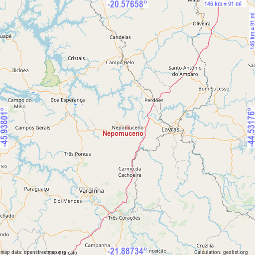
Nepomuceno GPS coordinates[2]
21° 14' 0.312" South, 45° 14' 5.568" West
| Map corner | latitude | longitude |
|---|---|---|
| Upper-left | -20.57658°, | -45.93801° |
| Center: | -21.23342°, | -45.23488° |
| Lower-right: | -21.88734°, | -44.53176° |
| Map W x H: | 145.7×145.7 km | = 90.5×90.5mi |
| max Lat: | 2.81972° ⇑64.8% North |
| Nepomuceno: | -21.23342° |
| min Lat: | ⇓35.2% South -33.69111° |
| min Long | Nepomuceno | max Long |
| -72.89583° | -45.23488° | -32.41083° |
| W 50.4%⇐ | ⇒49.6% E |
Elevation
Elevation of Nepomuceno is 849 m = 2785 ft, and this is 468.1 m = 1536 ft above average elevation for this country.
| Max E: |
1603 m = 5259 ft | 7.6% |
| Nepomuceno | 849 m 2785 ft | |
| Avg. | 380.9 m = 1250 ft | |
Min E: |
0 m = 0 ft | 92.4% |
See also: Brazil elevation on elevation.city.
Geographical zone
Nepomuceno is located in South Torrid zone (between Equator and Tropic of Capricorn). Distance of this Southern Tropic circle is 245 km =152.2 mi to South.| Distance of | km | miles | from Nepomuceno |
|---|---|---|---|
| Equator | 2360.9 | 1467 | to North |
| Tropic Capricorn | 245 | 152.2 | to South |
| Antarctic Circle | 5040.2 | 3131.8 | to South |
| South Pole | 7646.1 | 4751.1 | to South |


Nearby cities:
15 places around Nepomuceno: (largest is in red/bold)
• Boa Esperança
37.8 km =23.5 mi,  294°
294°
• Bom Sucesso
54.2 km =33.7 mi,  65°
65°
• Cambuquira
69.1 km =42.9 mi,  185°
185°
• Campanha
69.2 km =43 mi, 194°
• Campo Belo
37.6 km =23.4 mi,  353°
353°
• Campos Gerais
54.3 km =33.7 mi,  269°
269°
• Elói Mendes
54.1 km =33.6 mi,  219°
219°
• Lavras
24.4 km =15.2 mi,  93°
93°
• Oliveira
73.2 km =45.5 mi,  35°
35°
• Paraguaçu
62.7 km =39 mi,  236°
236°
• Perdões
21.7 km =13.5 mi, 43°
• Santo Antônio do Amparo
45.8 km =28.5 mi,  45°
45°
• Três Corações
51.6 km =32.1 mi,  182°
182°
• Três Pontas
32.4 km =20.1 mi, 242°
• Varginha
40.7 km =25.3 mi,  209°
209°
Sources, notices
• [Note1] Compared only with cities in Brazil existing in our database
• [Src1] Map data: © OpenStreetMap contributors (CC-BY-SA)
• [Src2] Other city data from geonames.org with taken over terms of usage.
• [Src3] Geographical zone / Annual Mean Temperature by Robert A. Rohde @ Wikipedia
