Campos Gerais geodata
Campos Gerais (Minas Gerais) is a populated place; located in Brazil in America/Sao_Paulo (GMT-3) time zone. With population of 22,260 people, there are 862 cities with bigger population in this country. Compared to other cities in Brazil, 64.9% of cities are located further ↑North; 51.8% of cities are located further →East and 91.7% of cities have lower elevation than Campos Gerais. Note1


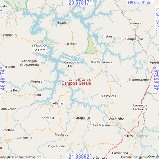
Campos Gerais GPS coordinates[2]
21° 14' 6" South, 45° 45' 30.996" West
| Map corner | latitude | longitude |
|---|---|---|
| Upper-left | -20.57817°, | -46.46174° |
| Center: | -21.235°, | -45.75861° |
| Lower-right: | -21.88892°, | -45.05549° |
| Map W x H: | 145.7×145.7 km | = 90.5×90.5mi |
| max Lat: | 2.81972° ⇑64.9% North |
| Campos Gerais: | -21.235° |
| min Lat: | ⇓35.1% South -33.69111° |
| min Long | Campos Gerais | max Long |
| -72.89583° | -45.75861° | -32.41083° |
| W 48.2%⇐ | ⇒51.8% E |
Elevation
Elevation of Campos Gerais is 840 m = 2756 ft, and this is 459.1 m = 1506 ft above average elevation for this country.
| Max E: |
1603 m = 5259 ft | 8.3% |
| Campos Gerais | 840 m 2756 ft | |
| Avg. | 380.9 m = 1250 ft | |
Min E: |
0 m = 0 ft | 91.7% |
See also: Brazil elevation on elevation.city.
Geographical zone
Campos Gerais is located in South Torrid zone (between Equator and Tropic of Capricorn). Distance of this Southern Tropic circle is 244.8 km =152.1 mi to South.| Distance of | km | miles | from Campos Gerais |
|---|---|---|---|
| Equator | 2361.1 | 1467.1 | to North |
| Tropic Capricorn | 244.8 | 152.1 | to South |
| Antarctic Circle | 5040.1 | 3131.8 | to South |
| South Pole | 7646 | 4751 | to South |


Nearby cities:
15 places around Campos Gerais: (largest is in red/bold)
• Alfenas
29.1 km =18.1 mi,  222°
222°
• Alterosa
39.9 km =24.8 mi,  267°
267°
• Areado
42.4 km =26.3 mi,  251°
251°
• Boa Esperança
25.7 km =16 mi,  51°
51°
• Campestre
73.1 km =45.4 mi, 223°
• Campo Belo
62.5 km =38.8 mi, 53°
• Carmo do Rio Claro
47.5 km =29.5 mi,  308°
308°
• Elói Mendes
46.2 km =28.7 mi,  154°
154°
• Machado
51.7 km =32.1 mi,  198°
198°
• Nepomuceno
54.3 km =33.7 mi,  89°
89°
• Paraguaçu
34.8 km =21.6 mi,  176°
176°
• Perdões
71 km =44.1 mi,  76°
76°
• Três Corações
73.3 km =45.5 mi,  134°
134°
• Três Pontas
29.4 km =18.3 mi,  119°
119°
• Varginha
48.9 km =30.4 mi,  135°
135°
Sources, notices
• [Note1] Compared only with cities in Brazil existing in our database
• [Src1] Map data: © OpenStreetMap contributors (CC-BY-SA)
• [Src2] Other city data from geonames.org with taken over terms of usage.
• [Src3] Geographical zone / Annual Mean Temperature by Robert A. Rohde @ Wikipedia
