Paraguaçu geodata
Paraguaçu (Minas Gerais) is a populated place; located in Brazil in America/Sao_Paulo (GMT-3) time zone. With population of 15,741 people, there are 1171 cities with bigger population in this country. Compared to other cities in Brazil, 66.9% of cities are located further ↑North; 51.8% of cities are located further →East and 90.8% of cities have lower elevation than Paraguaçu. Note1


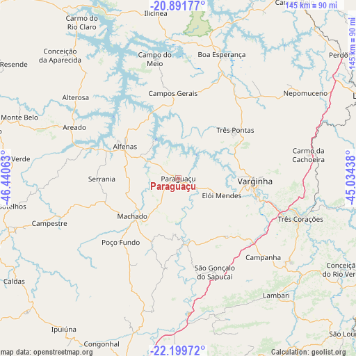
Paraguaçu GPS coordinates[2]
21° 32' 49.992" South, 45° 44' 15" West
| Map corner | latitude | longitude |
|---|---|---|
| Upper-left | -20.89177°, | -46.44063° |
| Center: | -21.54722°, | -45.7375° |
| Lower-right: | -22.19972°, | -45.03438° |
| Map W x H: | 145.4×145.4 km | = 90.3×90.3mi |
| max Lat: | 2.81972° ⇑66.9% North |
| Paraguaçu: | -21.54722° |
| min Lat: | ⇓33.1% South -33.69111° |
| min Long | Paraguaçu | max Long |
| -72.89583° | -45.7375° | -32.41083° |
| W 48.2%⇐ | ⇒51.8% E |
Elevation
Elevation of Paraguaçu is 825 m = 2707 ft, and this is 444.1 m = 1457 ft above average elevation for this country.
| Max E: |
1603 m = 5259 ft | 9.2% |
| Paraguaçu | 825 m 2707 ft | |
| Avg. | 380.9 m = 1250 ft | |
Min E: |
0 m = 0 ft | 90.8% |
See also: Brazil elevation on elevation.city.
Geographical zone
Paraguaçu is located in South Torrid zone (between Equator and Tropic of Capricorn). Distance of this Southern Tropic circle is 210.1 km =130.6 mi to South.| Distance of | km | miles | from Paraguaçu |
|---|---|---|---|
| Equator | 2395.8 | 1488.7 | to North |
| Tropic Capricorn | 210.1 | 130.6 | to South |
| Antarctic Circle | 5005.3 | 3110.1 | to South |
| South Pole | 7611.2 | 4729.4 | to South |


Nearby cities:
15 places around Paraguaçu: (largest is in red/bold)
• Alfenas
25.4 km =15.8 mi,  301°
301°
• Alterosa
53.5 km =33.2 mi,  308°
308°
• Areado
47.1 km =29.3 mi, 296°
• Boa Esperança
53.9 km =33.5 mi,  19°
19°
• Cambuquira
56.9 km =35.4 mi,  126°
126°
• Campanha
47.4 km =29.5 mi, 132°
• Campestre
55.7 km =34.6 mi,  250°
250°
• Campos Gerais
34.8 km =21.6 mi,  356°
356°
• Elói Mendes
19.1 km =11.9 mi,  111°
111°
• Lambari
62.2 km =38.6 mi,  139°
139°
• Machado
23.6 km =14.7 mi,  233°
233°
• São Gonçalo do Sapucaí
41.1 km =25.5 mi,  159°
159°
• Três Corações
52.7 km =32.7 mi, 108°
• Três Pontas
30.7 km =19.1 mi,  49°
49°
• Varginha
31.8 km =19.8 mi,  90°
90°
Sources, notices
• [Note1] Compared only with cities in Brazil existing in our database
• [Src1] Map data: © OpenStreetMap contributors (CC-BY-SA)
• [Src2] Other city data from geonames.org with taken over terms of usage.
• [Src3] Geographical zone / Annual Mean Temperature by Robert A. Rohde @ Wikipedia
