Machado geodata
Machado (Minas Gerais) is a populated place; located in Brazil in America/Sao_Paulo (GMT-3) time zone. With population of 33,002 people, there are 620 cities with bigger population in this country. Compared to other cities in Brazil, 67.7% of cities are located further ↑North; 52% of cities are located further →East and 90.1% of cities have lower elevation than Machado. Note1


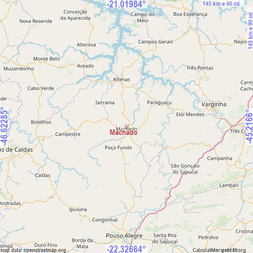
Machado GPS coordinates[2]
21° 40' 28.992" South, 45° 55' 10.992" West
| Map corner | latitude | longitude |
|---|---|---|
| Upper-left | -21.01984°, | -46.62285° |
| Center: | -21.67472°, | -45.91972° |
| Lower-right: | -22.32664°, | -45.2166° |
| Map W x H: | 145.3×145.3 km | = 90.3×90.3mi |
| max Lat: | 2.81972° ⇑67.7% North |
| Machado: | -21.67472° |
| min Lat: | ⇓32.3% South -33.69111° |
| min Long | Machado | max Long |
| -72.89583° | -45.91972° | -32.41083° |
| W 48%⇐ | ⇒52% E |
Elevation
Elevation of Machado is 815 m = 2674 ft, and this is 434.1 m = 1424 ft above average elevation for this country.
| Max E: |
1603 m = 5259 ft | 9.9% |
| Machado | 815 m 2674 ft | |
| Avg. | 380.9 m = 1250 ft | |
Min E: |
0 m = 0 ft | 90.1% |
See also: Brazil elevation on elevation.city.
Geographical zone
Machado is located in South Torrid zone (between Equator and Tropic of Capricorn). Distance of this Southern Tropic circle is 195.9 km =121.7 mi to South.| Distance of | km | miles | from Machado |
|---|---|---|---|
| Equator | 2410 | 1497.5 | to North |
| Tropic Capricorn | 195.9 | 121.7 | to South |
| Antarctic Circle | 4991.2 | 3101.4 | to South |
| South Pole | 7597.1 | 4720.6 | to South |


Nearby cities:
15 places around Machado: (largest is in red/bold)
• Alfenas
27.5 km =17.1 mi,  354°
354°
• Alterosa
52.7 km =32.7 mi,  333°
333°
• Areado
42.2 km =26.2 mi, 326°
• Botelhos
49.3 km =30.6 mi,  275°
275°
• Cambuquira
67.4 km =41.9 mi,  107°
107°
• Campanha
56.5 km =35.1 mi, 108°
• Campestre
34 km =21.1 mi,  263°
263°
• Campos Gerais
51.7 km =32.1 mi,  18°
18°
• Elói Mendes
37.3 km =23.2 mi,  78°
78°
• Paraguaçu
23.6 km =14.7 mi,  53°
53°
• Pouso Alegre
61.8 km =38.4 mi,  181°
181°
• Poços de Caldas
67.5 km =41.9 mi, 259°
• São Gonçalo do Sapucaí
41.3 km =25.7 mi,  125°
125°
• Três Pontas
54.3 km =33.7 mi, 50°
• Varginha
52.4 km =32.6 mi,  74°
74°
Sources, notices
• [Note1] Compared only with cities in Brazil existing in our database
• [Src1] Map data: © OpenStreetMap contributors (CC-BY-SA)
• [Src2] Other city data from geonames.org with taken over terms of usage.
• [Src3] Geographical zone / Annual Mean Temperature by Robert A. Rohde @ Wikipedia
