Itapetininga geodata
Itapetininga (São Paulo) is a populated place; located in Brazil in America/Sao_Paulo (GMT-3) time zone. With population of 126,243 people, there are 175 cities with bigger population in this country. Compared to other cities in Brazil, 83.6% of cities are located further ↑North; 64.9% of cities are located further →East and 78.2% of cities have lower elevation than Itapetininga. Note1


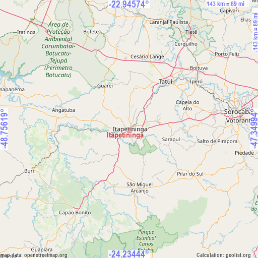
Itapetininga GPS coordinates[2]
23° 35' 30.012" South, 48° 3' 11.016" West
| Map corner | latitude | longitude |
|---|---|---|
| Upper-left | -22.94574°, | -48.75619° |
| Center: | -23.59167°, | -48.05306° |
| Lower-right: | -24.23444°, | -47.34994° |
| Map W x H: | 143.3×143.3 km | = 89×89mi |
| max Lat: | 2.81972° ⇑83.6% North |
| Itapetininga: | -23.59167° |
| min Lat: | ⇓16.4% South -33.69111° |
| min Long | Itapetininga | max Long |
| -72.89583° | -48.05306° | -32.41083° |
| W 35.1%⇐ | ⇒64.9% E |
Elevation
Elevation of Itapetininga is 670 m = 2198 ft, and this is 289.1 m = 948 ft above average elevation for this country.
| Max E: |
1603 m = 5259 ft | 21.8% |
| Itapetininga | 670 m 2198 ft | |
| Avg. | 380.9 m = 1250 ft | |
Min E: |
0 m = 0 ft | 78.2% |
See also: Itapetininga elevation on elevation.city.
Geographical zone
Itapetininga is located in South temperate zone (between Tropic of Capricorn and the Antarctic Circle). Distance of this Southern Tropic circle is 17.2 km =10.7 mi to North.| Distance of | km | miles | from Itapetininga |
|---|---|---|---|
| Equator | 2623.1 | 1629.9 | to North |
| Tropic Capricorn | 17.2 | 10.7 | to North |
| Antarctic Circle | 4778 | 2968.9 | to South |
| South Pole | 7383.9 | 4588.1 | to South |


Nearby cities:
15 places around Itapetininga: (largest is in red/bold)
• Angatuba
38.4 km =23.9 mi,  287°
287°
• Araçoiaba da Serra
45.8 km =28.5 mi,  77°
77°
• Boituva
51.8 km =32.2 mi,  48°
48°
• Buri
59.5 km =37 mi,  247°
247°
• Capela do Alto
35.1 km =21.8 mi,  67°
67°
• Capâo Bonito
55 km =34.2 mi,  213°
213°
• Cerquilho
57 km =35.4 mi,  33°
33°
• Conchas
64.2 km =39.9 mi,  3°
3°
• Iperó
45.8 km =28.5 mi, 54°
• Pilar do Sul
42.2 km =26.2 mi,  125°
125°
• Porangaba
46.8 km =29.1 mi,  350°
350°
• Salto de Pirapora
49.3 km =30.6 mi,  97°
97°
• Sorocaba
61.5 km =38.2 mi, 80°
• Tatuí
33 km =20.5 mi,  37°
37°
• Votorantim
62.9 km =39.1 mi,  85°
85°
Sources, notices
• [Note1] Compared only with cities in Brazil existing in our database
• [Src1] Map data: © OpenStreetMap contributors (CC-BY-SA)
• [Src2] Other city data from geonames.org with taken over terms of usage.
• [Src3] Geographical zone / Annual Mean Temperature by Robert A. Rohde @ Wikipedia
