Ourinhos geodata
Ourinhos (São Paulo) is a populated place; located in Brazil in America/Sao_Paulo (GMT-3) time zone. With population of 97,799 people, there are 239 cities with bigger population in this country. Compared to other cities in Brazil, 78.4% of cities are located further ↑North; 77.5% of cities are located further →East and 61.4% of cities have lower elevation than Ourinhos. Note1


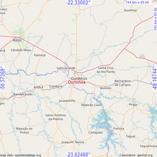
Ourinhos GPS coordinates[2]
22° 58' 44.004" South, 49° 52' 14.016" West
| Map corner | latitude | longitude |
|---|---|---|
| Upper-left | -22.33002°, | -50.57369° |
| Center: | -22.97889°, | -49.87056° |
| Lower-right: | -23.62466°, | -49.16744° |
| Map W x H: | 144×144 km | = 89.5×89.5mi |
| max Lat: | 2.81972° ⇑78.4% North |
| Ourinhos: | -22.97889° |
| min Lat: | ⇓21.6% South -33.69111° |
| min Long | Ourinhos | max Long |
| -72.89583° | -49.87056° | -32.41083° |
| W 22.5%⇐ | ⇒77.5% E |
Elevation
Elevation of Ourinhos is 488 m = 1601 ft, and this is 107.1 m = 351 ft above average elevation for this country.
| Max E: |
1603 m = 5259 ft | 38.6% |
| Ourinhos | 488 m 1601 ft | |
| Avg. | 380.9 m = 1250 ft | |
Min E: |
0 m = 0 ft | 61.4% |
See also: Ourinhos elevation on elevation.city.
Geographical zone
Ourinhos is located in South Torrid zone (between Equator and Tropic of Capricorn). Distance of this Southern Tropic circle is 50.9 km =31.6 mi to South.| Distance of | km | miles | from Ourinhos |
|---|---|---|---|
| Equator | 2555 | 1587.6 | to North |
| Tropic Capricorn | 50.9 | 31.6 | to South |
| Antarctic Circle | 4846.2 | 3011.3 | to South |
| South Pole | 7452 | 4630.5 | to South |


Nearby cities:
15 places around Ourinhos: (largest is in red/bold)
• Assis
65.8 km =40.9 mi,  302°
302°
• Bandeirantes
52.9 km =32.9 mi,  254°
254°
• Bernardino de Campos
40.7 km =25.3 mi,  95°
95°
• Cambará
22.1 km =13.7 mi, 250°
• Cerqueira César
72.4 km =45 mi,  94°
94°
• Chavantes
17.8 km =11.1 mi,  112°
112°
• Cândido Mota
58.9 km =36.6 mi, 296°
• Fartura
58.6 km =36.4 mi,  141°
141°
• Ipauçu
26.4 km =16.4 mi, 109°
• Jacarezinho
22.6 km =14 mi,  206°
206°
• Palmital
41.3 km =25.7 mi, 300°
• Piraju
55.2 km =34.3 mi,  115°
115°
• Santa Cruz do Rio Pardo
25.9 km =16.1 mi,  69°
69°
• Santo Antônio da Platina
41 km =25.5 mi, 211°
• Tarumã
76.9 km =47.8 mi,  289°
289°
Sources, notices
• [Note1] Compared only with cities in Brazil existing in our database
• [Src1] Map data: © OpenStreetMap contributors (CC-BY-SA)
• [Src2] Other city data from geonames.org with taken over terms of usage.
• [Src3] Geographical zone / Annual Mean Temperature by Robert A. Rohde @ Wikipedia
