Marília geodata
Marília (São Paulo) is a seat of a second-order administrative division; located in Brazil in America/Sao_Paulo (GMT-3) time zone. With population of 212,218 people, there are 107 cities with bigger population in this country. Compared to other cities in Brazil, 71.1% of cities are located further ↑North; 77.9% of cities are located further →East and 77.1% of cities have lower elevation than Marília. Note1


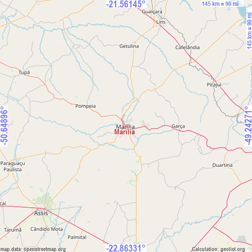
Marília GPS coordinates[2]
22° 12' 50.004" South, 49° 56' 44.988" West
| Map corner | latitude | longitude |
|---|---|---|
| Upper-left | -21.56145°, | -50.64896° |
| Center: | -22.21389°, | -49.94583° |
| Lower-right: | -22.86331°, | -49.24271° |
| Map W x H: | 144.8×144.8 km | = 90×90mi |
| max Lat: | 2.81972° ⇑71.1% North |
| Marília: | -22.21389° |
| min Lat: | ⇓28.9% South -33.69111° |
| min Long | Marília | max Long |
| -72.89583° | -49.94583° | -32.41083° |
| W 22.1%⇐ | ⇒77.9% E |
Elevation
Elevation of Marília is 655 m = 2149 ft, and this is 274.1 m = 899 ft above average elevation for this country.
| Max E: |
1603 m = 5259 ft | 22.9% |
| Marília | 655 m 2149 ft | |
| Avg. | 380.9 m = 1250 ft | |
Min E: |
0 m = 0 ft | 77.1% |
See also: Marília elevation on elevation.city.
Geographical zone
Marília is located in South Torrid zone (between Equator and Tropic of Capricorn). Distance of this Southern Tropic circle is 136 km =84.5 mi to South.| Distance of | km | miles | from Marília |
|---|---|---|---|
| Equator | 2470 | 1534.8 | to North |
| Tropic Capricorn | 136 | 84.5 | to South |
| Antarctic Circle | 4931.2 | 3064.1 | to South |
| South Pole | 7537.1 | 4683.3 | to South |


Nearby cities:
15 places around Marília: (largest is in red/bold)
• Assis
69.1 km =42.9 mi,  223°
223°
• Cafelândia
57.4 km =35.7 mi,  37°
37°
• Cândido Mota
74.6 km =46.4 mi, 217°
• Duartina
60 km =37.3 mi,  111°
111°
• Garça
29.8 km =18.5 mi,  89°
89°
• Lins
63.1 km =39.2 mi,  19°
19°
• Ourinhos
85.4 km =53.1 mi,  174°
174°
• Palmital
69.8 km =43.4 mi,  203°
203°
• Paraguaçu Paulista
68.5 km =42.6 mi,  251°
251°
• Pirajuí
55.7 km =34.6 mi,  64°
64°
• Pompéia
26 km =16.2 mi,  296°
296°
• Promissão
75.8 km =47.1 mi,  6°
6°
• Quatá
77.5 km =48.2 mi,  267°
267°
• Santa Cruz do Rio Pardo
82.7 km =51.4 mi,  157°
157°
• Tupã
66.2 km =41.1 mi, 297°
Sources, notices
• [Note1] Compared only with cities in Brazil existing in our database
• [Src1] Map data: © OpenStreetMap contributors (CC-BY-SA)
• [Src2] Other city data from geonames.org with taken over terms of usage.
• [Src3] Geographical zone / Annual Mean Temperature by Robert A. Rohde @ Wikipedia
