Candelária geodata
Candelária (Rio Grande do Sul) is a populated place; located in Brazil in America/Sao_Paulo (GMT-3) time zone. With population of 30,171 people, there are 668 cities with bigger population in this country. Compared to other cities in Brazil, 97.4% of cities are located further ↑North; 90% of cities are located further →East and 78.9% of cities have higher elevation than Candelária. Note1


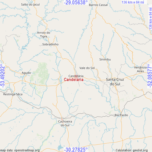
Candelária GPS coordinates[2]
29° 40' 9.012" South, 52° 47' 20.004" West
| Map corner | latitude | longitude |
|---|---|---|
| Upper-left | -29.05638°, | -53.49202° |
| Center: | -29.66917°, | -52.78889° |
| Lower-right: | -30.27825°, | -52.08577° |
| Map W x H: | 135.9×135.9 km | = 84.4×84.4mi |
| max Lat: | 2.81972° ⇑97.4% North |
| Candelária: | -29.66917° |
| min Lat: | ⇓2.6% South -33.69111° |
| min Long | Candelária | max Long |
| -72.89583° | -52.78889° | -32.41083° |
| W 10%⇐ | ⇒90% E |
Elevation
Elevation of Candelária is 53 m = 174 ft, and this is 327.9 m = 1076 ft below average elevation for this country.
| Max E: |
1603 m = 5259 ft | 78.9% |
| Avg. | 380.9 m = 1250 ft | |
| Candelária | 53 m = 174 ft | |
Min E: |
0 m = 0 ft | 21.1% |
See also: Brazil elevation on elevation.city.
Geographical zone
Candelária is located in South temperate zone (between Tropic of Capricorn and the Antarctic Circle). Distance of this Southern Tropic circle is 693 km =430.6 mi to North.| Distance of | km | miles | from Candelária |
|---|---|---|---|
| Equator | 3298.9 | 2049.8 | to North |
| Tropic Capricorn | 693 | 430.6 | to North |
| Antarctic Circle | 4102.3 | 2549.1 | to South |
| South Pole | 6708.2 | 4168.3 | to South |


Nearby cities:
15 places around Candelária: (largest is in red/bold)
• Arroio do Meio
86.9 km =54 mi,  69°
69°
• Butiá
94.1 km =58.5 mi,  122°
122°
• Cachoeira do Sul
42.4 km =26.3 mi,  193°
193°
• Encruzilhada do Sul
100.6 km =62.5 mi,  165°
165°
• Júlio de Castilhos
99.4 km =61.8 mi,  299°
299°
• Lajeado
83.1 km =51.6 mi, 74°
• Pinheiros
13.8 km =8.6 mi,  157°
157°
• Rio Pardo
53.3 km =33.1 mi,  131°
131°
• Santa Cruz do Sul
35.5 km =22.1 mi,  98°
98°
• Santa Maria
98.4 km =61.1 mi,  269°
269°
• Soledade
98.4 km =61.1 mi,  15°
15°
• São Sepé
92.6 km =57.5 mi,  233°
233°
• Taquari
90.4 km =56.2 mi, 99°
• Teutônia
98.2 km =61 mi,  75°
75°
• Venâncio Aires
58.1 km =36.1 mi, 83°
Sources, notices
• [Note1] Compared only with cities in Brazil existing in our database
• [Src1] Map data: © OpenStreetMap contributors (CC-BY-SA)
• [Src2] Other city data from geonames.org with taken over terms of usage.
• [Src3] Geographical zone / Annual Mean Temperature by Robert A. Rohde @ Wikipedia
