Lajeado geodata
Lajeado (Rio Grande do Sul) is a populated place; located in Brazil in America/Sao_Paulo (GMT-3) time zone. With population of 65,407 people, there are 338 cities with bigger population in this country. Compared to other cities in Brazil, 96.8% of cities are located further ↑North; 87.6% of cities are located further →East and 86% of cities have higher elevation than Lajeado. Note1


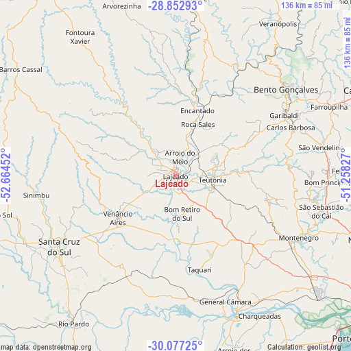
Lajeado GPS coordinates[2]
29° 28' 0.984" South, 51° 57' 41.004" West
| Map corner | latitude | longitude |
|---|---|---|
| Upper-left | -28.85293°, | -52.66452° |
| Center: | -29.46694°, | -51.96139° |
| Lower-right: | -30.07725°, | -51.25827° |
| Map W x H: | 136.1×136.1 km | = 84.6×84.6mi |
| max Lat: | 2.81972° ⇑96.8% North |
| Lajeado: | -29.46694° |
| min Lat: | ⇓3.2% South -33.69111° |
| min Long | Lajeado | max Long |
| -72.89583° | -51.96139° | -32.41083° |
| W 12.4%⇐ | ⇒87.6% E |
Elevation
Elevation of Lajeado is 28 m = 92 ft, and this is 352.9 m = 1158 ft below average elevation for this country.
| Max E: |
1603 m = 5259 ft | 86% |
| Avg. | 380.9 m = 1250 ft | |
| Lajeado | 28 m = 92 ft | |
Min E: |
0 m = 0 ft | 14% |
See also: Lajeado elevation on elevation.city.
Geographical zone
Lajeado is located in South temperate zone (between Tropic of Capricorn and the Antarctic Circle). Distance of this Southern Tropic circle is 670.5 km =416.6 mi to North.| Distance of | km | miles | from Lajeado |
|---|---|---|---|
| Equator | 3276.4 | 2035.9 | to North |
| Tropic Capricorn | 670.5 | 416.6 | to North |
| Antarctic Circle | 4124.8 | 2563 | to South |
| South Pole | 6730.6 | 4182.2 | to South |


Nearby cities:
15 places around Lajeado: (largest is in red/bold)
• Arroio do Meio
7.5 km =4.7 mi,  12°
12°
• Bento Gonçalves
54 km =33.6 mi,  52°
52°
• Carlos Barbosa
48.2 km =30 mi,  66°
66°
• Charqueadas
63.2 km =39.3 mi,  149°
149°
• Encantado
27.2 km =16.9 mi,  19°
19°
• Farroupilha
65.3 km =40.6 mi, 65°
• Garibaldi
47.6 km =29.6 mi,  60°
60°
• Montenegro
54.3 km =33.7 mi,  116°
116°
• Santa Cruz do Sul
52.8 km =32.8 mi,  238°
238°
• São Jerônimo
59.4 km =36.9 mi,  157°
157°
• São Sebastião do Caí
58.2 km =36.2 mi,  103°
103°
• Taquari
38.2 km =23.7 mi,  165°
165°
• Teutônia
15.2 km =9.4 mi,  82°
82°
• Triunfo
57.9 km =36 mi, 156°
• Venâncio Aires
27.2 km =16.9 mi, 235°
Sources, notices
• [Note1] Compared only with cities in Brazil existing in our database
• [Src1] Map data: © OpenStreetMap contributors (CC-BY-SA)
• [Src2] Other city data from geonames.org with taken over terms of usage.
• [Src3] Geographical zone / Annual Mean Temperature by Robert A. Rohde @ Wikipedia
