Soledade geodata
Soledade (Rio Grande do Sul) is a populated place; located in Brazil in America/Sao_Paulo (GMT-3) time zone. With population of 24,791 people, there are 787 cities with bigger population in this country. Compared to other cities in Brazil, 95.7% of cities are located further ↑North; 89.2% of cities are located further →East and 82% of cities have lower elevation than Soledade. Note1


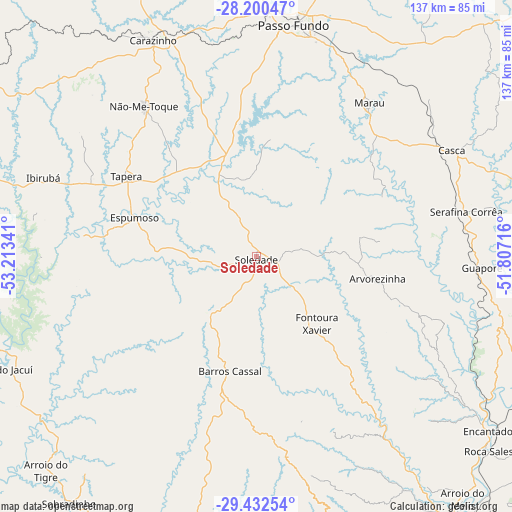
Soledade GPS coordinates[2]
28° 49' 5.988" South, 52° 30' 37.008" West
| Map corner | latitude | longitude |
|---|---|---|
| Upper-left | -28.20047°, | -53.21341° |
| Center: | -28.81833°, | -52.51028° |
| Lower-right: | -29.43254°, | -51.80716° |
| Map W x H: | 137×137 km | = 85.1×85.1mi |
| max Lat: | 2.81972° ⇑95.7% North |
| Soledade: | -28.81833° |
| min Lat: | ⇓4.3% South -33.69111° |
| min Long | Soledade | max Long |
| -72.89583° | -52.51028° | -32.41083° |
| W 10.8%⇐ | ⇒89.2% E |
Elevation
Elevation of Soledade is 717 m = 2352 ft, and this is 336.1 m = 1103 ft above average elevation for this country.
| Max E: |
1603 m = 5259 ft | 18% |
| Soledade | 717 m 2352 ft | |
| Avg. | 380.9 m = 1250 ft | |
Min E: |
0 m = 0 ft | 82% |
See also: Brazil elevation on elevation.city.
Geographical zone
Soledade is located in South temperate zone (between Tropic of Capricorn and the Antarctic Circle). Distance of this Southern Tropic circle is 598.4 km =371.8 mi to North.| Distance of | km | miles | from Soledade |
|---|---|---|---|
| Equator | 3204.3 | 1991.1 | to North |
| Tropic Capricorn | 598.4 | 371.8 | to North |
| Antarctic Circle | 4196.9 | 2607.8 | to South |
| South Pole | 6802.8 | 4227.1 | to South |


Nearby cities:
15 places around Soledade: (largest is in red/bold)
• Arroio do Meio
84.9 km =52.8 mi,  139°
139°
• Carazinho
65.3 km =40.6 mi,  335°
335°
• Encantado
77.7 km =48.3 mi,  126°
126°
• Espumoso
34.7 km =21.6 mi,  287°
287°
• Guaporé
60.5 km =37.6 mi,  92°
92°
• Ibirubá
60.4 km =37.5 mi, 290°
• Lajeado
89.7 km =55.7 mi, 143°
• Marau
51 km =31.7 mi,  36°
36°
• Nova Prata
87.8 km =54.6 mi, 87°
• Não Me Toque
50.1 km =31.1 mi,  322°
322°
• Passo Fundo
62.6 km =38.9 mi,  9°
9°
• Tapejara
96.5 km =60 mi,  30°
30°
• Teutônia
97.9 km =60.8 mi, 135°
• Venâncio Aires
92.9 km =57.7 mi,  160°
160°
• Veranópolis
94.5 km =58.7 mi,  97°
97°
Sources, notices
• [Note1] Compared only with cities in Brazil existing in our database
• [Src1] Map data: © OpenStreetMap contributors (CC-BY-SA)
• [Src2] Other city data from geonames.org with taken over terms of usage.
• [Src3] Geographical zone / Annual Mean Temperature by Robert A. Rohde @ Wikipedia
