Cacequi geodata
Cacequi (Rio Grande do Sul) is a populated place; located in Brazil in America/Sao_Paulo (GMT-3) time zone. With population of 12,867 people, there are 1381 cities with bigger population in this country. Compared to other cities in Brazil, 98.1% of cities are located further ↑North; 94% of cities are located further →East and 71.4% of cities have higher elevation than Cacequi. Note1


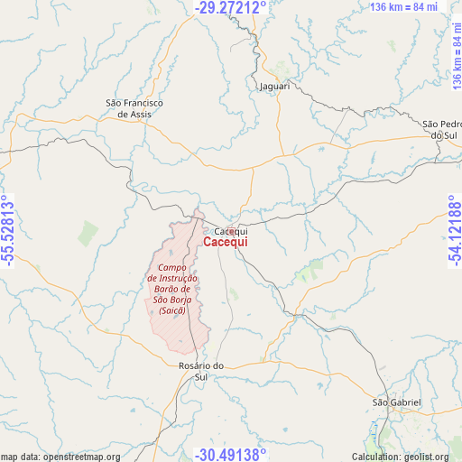
Cacequi GPS coordinates[2]
29° 53' 0.996" South, 54° 49' 30" West
| Map corner | latitude | longitude |
|---|---|---|
| Upper-left | -29.27212°, | -55.52813° |
| Center: | -29.88361°, | -54.825° |
| Lower-right: | -30.49138°, | -54.12188° |
| Map W x H: | 135.6×135.6 km | = 84.3×84.3mi |
| max Lat: | 2.81972° ⇑98.1% North |
| Cacequi: | -29.88361° |
| min Lat: | ⇓1.9% South -33.69111° |
| min Long | Cacequi | max Long |
| -72.89583° | -54.825° | -32.41083° |
| W 6%⇐ | ⇒94% E |
Elevation
Elevation of Cacequi is 112 m = 367 ft, and this is 268.9 m = 882 ft below average elevation for this country.
| Max E: |
1603 m = 5259 ft | 71.4% |
| Avg. | 380.9 m = 1250 ft | |
| Cacequi | 112 m = 367 ft | |
Min E: |
0 m = 0 ft | 28.6% |
See also: Brazil elevation on elevation.city.
Geographical zone
Cacequi is located in South temperate zone (between Tropic of Capricorn and the Antarctic Circle). Distance of this Southern Tropic circle is 716.8 km =445.4 mi to North.| Distance of | km | miles | from Cacequi |
|---|---|---|---|
| Equator | 3322.7 | 2064.6 | to North |
| Tropic Capricorn | 716.8 | 445.4 | to North |
| Antarctic Circle | 4078.4 | 2534.2 | to South |
| South Pole | 6684.3 | 4153.4 | to South |


Nearby cities:
15 places around Cacequi: (largest is in red/bold)
• Alegrete
93.9 km =58.3 mi,  276°
276°
• Caçapava do Sul
146.6 km =91.1 mi,  118°
118°
• Dom Pedrito
123.1 km =76.5 mi,  173°
173°
• Júlio de Castilhos
132.5 km =82.3 mi,  56°
56°
• Quaraí
166.1 km =103.2 mi,  250°
250°
• Rosário do Sul
42.5 km =26.4 mi,  191°
191°
• Santa Maria
100.7 km =62.6 mi,  77°
77°
• Santana do Livramento
131 km =81.4 mi,  211°
211°
• Santiago
77 km =47.8 mi,  356°
356°
• São Francisco de Assis
47.4 km =29.5 mi,  321°
321°
• São Gabriel
70 km =43.5 mi,  136°
136°
• São Luiz Gonzaga
164.6 km =102.3 mi, 355°
• São Pedro do Sul
68.9 km =42.8 mi, 64°
• São Sepé
125.1 km =77.7 mi,  104°
104°
• Tupanciretã
130.9 km =81.3 mi,  46°
46°
Sources, notices
• [Note1] Compared only with cities in Brazil existing in our database
• [Src1] Map data: © OpenStreetMap contributors (CC-BY-SA)
• [Src2] Other city data from geonames.org with taken over terms of usage.
• [Src3] Geographical zone / Annual Mean Temperature by Robert A. Rohde @ Wikipedia
