Santana do Livramento geodata
Santana do Livramento (Rio Grande do Sul) is a populated place; located in Brazil in America/Sao_Paulo (GMT-3) time zone. With population of 89,694 people, there are 257 cities with bigger population in this country. Compared to other cities in Brazil, 99.4% of cities are located further ↑North; 94.7% of cities are located further →East and 60% of cities have higher elevation than Santana do Livramento. Note1


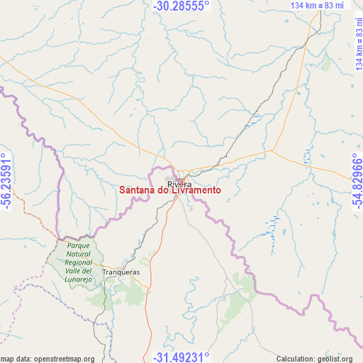
Santana do Livramento GPS coordinates[2]
30° 53' 26.988" South, 55° 31' 58.008" West
| Map corner | latitude | longitude |
|---|---|---|
| Upper-left | -30.28555°, | -56.23591° |
| Center: | -30.89083°, | -55.53278° |
| Lower-right: | -31.49231°, | -54.82966° |
| Map W x H: | 134.2×134.2 km | = 83.4×83.4mi |
| max Lat: | 2.81972° ⇑99.4% North |
| Santana do Livramento: | -30.89083° |
| min Lat: | ⇓0.6% South -33.69111° |
| min Long | Santana do Livr | max Long |
| -72.89583° | -55.53278° | -32.41083° |
| W 5.3%⇐ | ⇒94.7% E |
Elevation
Elevation of Santana do Livramento is 213 m = 699 ft, and this is 167.9 m = 551 ft below average elevation for this country.
| Max E: |
1603 m = 5259 ft | 60% |
| Avg. | 380.9 m = 1250 ft | |
| Santana do Livramento | 213 m = 699 ft | |
Min E: |
0 m = 0 ft | 40% |
See also: Santana do Livramento elevation on elevation.city.
Geographical zone
Santana do Livramento is located in South temperate zone (between Tropic of Capricorn and the Antarctic Circle). Distance of this Southern Tropic circle is 828.8 km =515 mi to North.| Distance of | km | miles | from Santana do Livramento |
|---|---|---|---|
| Equator | 3434.7 | 2134.2 | to North |
| Tropic Capricorn | 828.8 | 515 | to North |
| Antarctic Circle | 3966.4 | 2464.6 | to South |
| South Pole | 6572.3 | 4083.8 | to South |


Nearby cities:
15 places around Santana do Livramento: (largest is in red/bold)
• Alegrete
125.7 km =78.1 mi,  348°
348°
• Bagé
144.3 km =89.7 mi,  109°
109°
• Cacequi
131 km =81.4 mi,  31°
31°
• Caçapava do Sul
200.2 km =124.4 mi,  77°
77°
• Dom Pedrito
82.6 km =51.3 mi,  97°
97°
• Pinheiro Machado
218.4 km =135.7 mi, 110°
• Quaraí
104.2 km =64.7 mi,  302°
302°
• Rosário do Sul
91.9 km =57.1 mi,  40°
40°
• Santa Maria
213.2 km =132.5 mi,  51°
51°
• Santiago
199.5 km =124 mi,  18°
18°
• São Francisco de Assis
154 km =95.7 mi,  14°
14°
• São Gabriel
131.4 km =81.6 mi,  62°
62°
• São Pedro do Sul
192 km =119.3 mi, 42°
• São Sepé
205.2 km =127.5 mi,  66°
66°
• Uruguaiana
195.6 km =121.5 mi,  310°
310°
Sources, notices
• [Note1] Compared only with cities in Brazil existing in our database
• [Src1] Map data: © OpenStreetMap contributors (CC-BY-SA)
• [Src2] Other city data from geonames.org with taken over terms of usage.
• [Src3] Geographical zone / Annual Mean Temperature by Robert A. Rohde @ Wikipedia
