Cafelândia geodata
Cafelândia (São Paulo) is a populated place; located in Brazil in America/Sao_Paulo (GMT-3) time zone. With population of 13,777 people, there are 1309 cities with bigger population in this country. Compared to other cities in Brazil, 68.7% of cities are located further ↑North; 76.2% of cities are located further →East and 57.8% of cities have lower elevation than Cafelândia. Note1


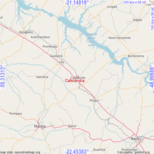
Cafelândia GPS coordinates[2]
21° 48' 9" South, 49° 36' 36" West
| Map corner | latitude | longitude |
|---|---|---|
| Upper-left | -21.14819°, | -50.31313° |
| Center: | -21.8025°, | -49.61° |
| Lower-right: | -22.45383°, | -48.90688° |
| Map W x H: | 145.2×145.2 km | = 90.2×90.2mi |
| max Lat: | 2.81972° ⇑68.7% North |
| Cafelândia: | -21.8025° |
| min Lat: | ⇓31.3% South -33.69111° |
| min Long | Cafelândia | max Long |
| -72.89583° | -49.61° | -32.41083° |
| W 23.8%⇐ | ⇒76.2% E |
Elevation
Elevation of Cafelândia is 450 m = 1476 ft, and this is 69.1 m = 227 ft above average elevation for this country.
| Max E: |
1603 m = 5259 ft | 42.2% |
| Cafelândia | 450 m 1476 ft | |
| Avg. | 380.9 m = 1250 ft | |
Min E: |
0 m = 0 ft | 57.8% |
See also: Brazil elevation on elevation.city.
Geographical zone
Cafelândia is located in South Torrid zone (between Equator and Tropic of Capricorn). Distance of this Southern Tropic circle is 181.7 km =112.9 mi to South.| Distance of | km | miles | from Cafelândia |
|---|---|---|---|
| Equator | 2424.2 | 1506.3 | to North |
| Tropic Capricorn | 181.7 | 112.9 | to South |
| Antarctic Circle | 4977 | 3092.6 | to South |
| South Pole | 7582.9 | 4711.8 | to South |


Nearby cities:
15 places around Cafelândia: (largest is in red/bold)
• Bauru
80.3 km =49.9 mi,  135°
135°
• Borborema
59 km =36.7 mi,  69°
69°
• Duartina
71.3 km =44.3 mi,  162°
162°
• Garça
45.6 km =28.3 mi,  185°
185°
• Ibitinga
80.8 km =50.2 mi,  86°
86°
• Itajobi
78.8 km =49 mi,  46°
46°
• José Bonifácio
83.8 km =52.1 mi,  354°
354°
• Lins
19.4 km =12.1 mi,  315°
315°
• Marília
57.4 km =35.7 mi,  217°
217°
• Novo Horizonte
54.8 km =34.1 mi, 47°
• Penápolis
64.4 km =40 mi,  311°
311°
• Pirajuí
26.9 km =16.7 mi, 144°
• Pompéia
67.2 km =41.8 mi,  239°
239°
• Promissão
39.1 km =24.3 mi, 319°
• Urupês
74.6 km =46.4 mi,  26°
26°
Sources, notices
• [Note1] Compared only with cities in Brazil existing in our database
• [Src1] Map data: © OpenStreetMap contributors (CC-BY-SA)
• [Src2] Other city data from geonames.org with taken over terms of usage.
• [Src3] Geographical zone / Annual Mean Temperature by Robert A. Rohde @ Wikipedia
