Pirajuí geodata
Pirajuí (São Paulo) is a populated place; located in Brazil in America/Sao_Paulo (GMT-3) time zone. With population of 17,503 people, there are 1066 cities with bigger population in this country. Compared to other cities in Brazil, 70.1% of cities are located further ↑North; 75.2% of cities are located further →East and 62.2% of cities have lower elevation than Pirajuí. Note1


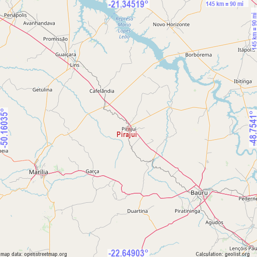
Pirajuí GPS coordinates[2]
21° 59' 54.996" South, 49° 27' 25.992" West
| Map corner | latitude | longitude |
|---|---|---|
| Upper-left | -21.34519°, | -50.16035° |
| Center: | -21.99861°, | -49.45722° |
| Lower-right: | -22.64903°, | -48.7541° |
| Map W x H: | 145×145 km | = 90.1×90.1mi |
| max Lat: | 2.81972° ⇑70.1% North |
| Pirajuí: | -21.99861° |
| min Lat: | ⇓29.9% South -33.69111° |
| min Long | Pirajuí | max Long |
| -72.89583° | -49.45722° | -32.41083° |
| W 24.8%⇐ | ⇒75.2% E |
Elevation
Elevation of Pirajuí is 499 m = 1637 ft, and this is 118.1 m = 387 ft above average elevation for this country.
| Max E: |
1603 m = 5259 ft | 37.8% |
| Pirajuí | 499 m 1637 ft | |
| Avg. | 380.9 m = 1250 ft | |
Min E: |
0 m = 0 ft | 62.2% |
See also: Brazil elevation on elevation.city.
Geographical zone
Pirajuí is located in South Torrid zone (between Equator and Tropic of Capricorn). Distance of this Southern Tropic circle is 159.9 km =99.4 mi to South.| Distance of | km | miles | from Pirajuí |
|---|---|---|---|
| Equator | 2446 | 1519.9 | to North |
| Tropic Capricorn | 159.9 | 99.4 | to South |
| Antarctic Circle | 4955.2 | 3079 | to South |
| South Pole | 7561 | 4698.2 | to South |


Nearby cities:
15 places around Pirajuí: (largest is in red/bold)
• Agudos
71.2 km =44.2 mi,  137°
137°
• Bariri
74.4 km =46.2 mi,  96°
96°
• Bauru
53.9 km =33.5 mi,  130°
130°
• Boracéia
73.2 km =45.5 mi,  107°
107°
• Borborema
57.8 km =35.9 mi,  43°
43°
• Cafelândia
26.9 km =16.7 mi,  324°
324°
• Duartina
46.6 km =29 mi,  173°
173°
• Garça
31.2 km =19.4 mi,  221°
221°
• Ibitinga
70.1 km =43.6 mi,  67°
67°
• Itápolis
80.2 km =49.8 mi,  56°
56°
• Lins
46.2 km =28.7 mi, 320°
• Marília
55.7 km =34.6 mi,  244°
244°
• Novo Horizonte
63.8 km =39.6 mi,  22°
22°
• Pompéia
74.6 km =46.4 mi,  260°
260°
• Promissão
66 km =41 mi, 321°
Sources, notices
• [Note1] Compared only with cities in Brazil existing in our database
• [Src1] Map data: © OpenStreetMap contributors (CC-BY-SA)
• [Src2] Other city data from geonames.org with taken over terms of usage.
• [Src3] Geographical zone / Annual Mean Temperature by Robert A. Rohde @ Wikipedia
