Alegre geodata
Alegre (Espírito Santo) is a populated place; located in Brazil in America/Sao_Paulo (GMT-3) time zone. With population of 19,757 people, there are 950 cities with bigger population in this country. Compared to other cities in Brazil, 61.6% of cities are located further ↑North; 67.9% of cities are located further ←West and 56.6% of cities have higher elevation than Alegre. Note1


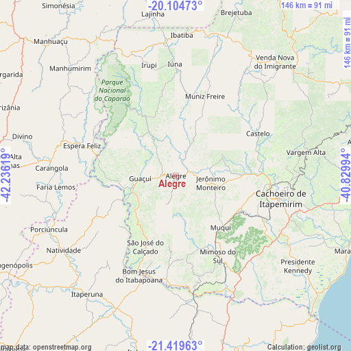
Alegre GPS coordinates[2]
20° 45' 48.996" South, 41° 31' 59.016" West
| Map corner | latitude | longitude |
|---|---|---|
| Upper-left | -20.10473°, | -42.23619° |
| Center: | -20.76361°, | -41.53306° |
| Lower-right: | -21.41963°, | -40.82994° |
| Map W x H: | 146.2×146.2 km | = 90.8×90.8mi |
| max Lat: | 2.81972° ⇑61.6% North |
| Alegre: | -20.76361° |
| min Lat: | ⇓38.4% South -33.69111° |
| min Long | Alegre | max Long |
| -72.89583° | -41.53306° | -32.41083° |
| W 67.9%⇐ | ⇒32.1% E |
Elevation
Elevation of Alegre is 248 m = 814 ft, and this is 132.9 m = 436 ft below average elevation for this country.
| Max E: |
1603 m = 5259 ft | 56.6% |
| Avg. | 380.9 m = 1250 ft | |
| Alegre | 248 m = 814 ft | |
Min E: |
0 m = 0 ft | 43.4% |
See also: Brazil elevation on elevation.city.
Geographical zone
Alegre is located in South Torrid zone (between Equator and Tropic of Capricorn). Distance of this Southern Tropic circle is 297.2 km =184.7 mi to South.| Distance of | km | miles | from Alegre |
|---|---|---|---|
| Equator | 2308.7 | 1434.6 | to North |
| Tropic Capricorn | 297.2 | 184.7 | to South |
| Antarctic Circle | 5092.5 | 3164.3 | to South |
| South Pole | 7698.4 | 4783.6 | to South |


Nearby cities:
15 places around Alegre: (largest is in red/bold)
• Bom Jesus do Itabapoana
43.9 km =27.3 mi,  200°
200°
• Cachoeiro de Itapemirim
44.7 km =27.8 mi,  102°
102°
• Carangola
51.7 km =32.1 mi,  273°
273°
• Castelo
40.4 km =25.1 mi,  63°
63°
• Conceição do Castelo
53.3 km =33.1 mi,  34°
34°
• Espera Feliz
40.9 km =25.4 mi,  287°
287°
• Guaçuí
15.3 km =9.5 mi, 265°
• Irupi
47.9 km =29.8 mi,  346°
346°
• Iúna
46.5 km =28.9 mi,  359°
359°
• Jerônimo Monteiro
14.6 km =9.1 mi, 101°
• Mimoso do Sul
37.6 km =23.4 mi,  152°
152°
• Muniz Freire
35.6 km =22.1 mi,  20°
20°
• Natividade
55.2 km =34.3 mi,  235°
235°
• São José do Calçado
31.7 km =19.7 mi, 203°
• Vargem Alta
55.7 km =34.6 mi,  79°
79°
Sources, notices
• [Note1] Compared only with cities in Brazil existing in our database
• [Src1] Map data: © OpenStreetMap contributors (CC-BY-SA)
• [Src2] Other city data from geonames.org with taken over terms of usage.
• [Src3] Geographical zone / Annual Mean Temperature by Robert A. Rohde @ Wikipedia
