Muniz Freire geodata
Muniz Freire (Espírito Santo) is a populated place; located in Brazil in America/Sao_Paulo (GMT-3) time zone. With population of 8,312 people, there are 1761 cities with bigger population in this country. Compared to other cities in Brazil, 59.9% of cities are located further ↑North; 68.6% of cities are located further ←West and 67.7% of cities have lower elevation than Muniz Freire. Note1


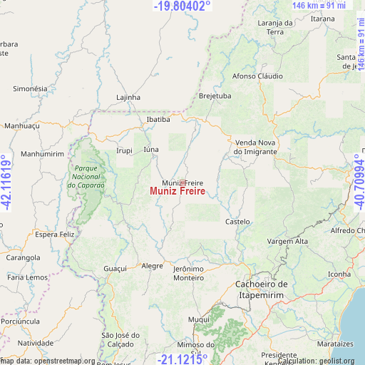
Muniz Freire GPS coordinates[2]
20° 27' 51.012" South, 41° 24' 47.016" West
| Map corner | latitude | longitude |
|---|---|---|
| Upper-left | -19.80402°, | -42.11619° |
| Center: | -20.46417°, | -41.41306° |
| Lower-right: | -21.1215°, | -40.70994° |
| Map W x H: | 146.5×146.5 km | = 91×91mi |
| max Lat: | 2.81972° ⇑59.9% North |
| Muniz Freire: | -20.46417° |
| min Lat: | ⇓40.1% South -33.69111° |
| min Long | Muniz Freire | max Long |
| -72.89583° | -41.41306° | -32.41083° |
| W 68.6%⇐ | ⇒31.4% E |
Elevation
Elevation of Muniz Freire is 555 m = 1821 ft, and this is 174.1 m = 571 ft above average elevation for this country.
| Max E: |
1603 m = 5259 ft | 32.3% |
| Muniz Freire | 555 m 1821 ft | |
| Avg. | 380.9 m = 1250 ft | |
Min E: |
0 m = 0 ft | 67.7% |
See also: Brazil elevation on elevation.city.
Geographical zone
Muniz Freire is located in South Torrid zone (between Equator and Tropic of Capricorn). Distance of this Southern Tropic circle is 330.5 km =205.4 mi to South.| Distance of | km | miles | from Muniz Freire |
|---|---|---|---|
| Equator | 2275.4 | 1413.9 | to North |
| Tropic Capricorn | 330.5 | 205.4 | to South |
| Antarctic Circle | 5125.8 | 3185 | to South |
| South Pole | 7731.7 | 4804.3 | to South |


Nearby cities:
15 places around Muniz Freire: (largest is in red/bold)
• Afonso Cláudio
52.8 km =32.8 mi,  34°
34°
• Alegre
35.6 km =22.1 mi,  200°
200°
• Cachoeiro de Itapemirim
53 km =32.9 mi,  143°
143°
• Castelo
28.4 km =17.6 mi,  123°
123°
• Conceição do Castelo
20.6 km =12.8 mi,  58°
58°
• Espera Feliz
55.5 km =34.5 mi,  248°
248°
• Guaçuí
44.4 km =27.6 mi,  218°
218°
• Ibatiba
27.5 km =17.1 mi,  338°
338°
• Irupi
27.2 km =16.9 mi,  299°
299°
• Iúna
18.4 km =11.4 mi,  315°
315°
• Jerônimo Monteiro
36.2 km =22.5 mi,  177°
177°
• Lajinha
41.1 km =25.5 mi,  327°
327°
• Manhumirim
58 km =36 mi,  281°
281°
• Rio Novo do Sul
66.5 km =41.3 mi,  131°
131°
• Vargem Alta
48.1 km =29.9 mi, 118°
Sources, notices
• [Note1] Compared only with cities in Brazil existing in our database
• [Src1] Map data: © OpenStreetMap contributors (CC-BY-SA)
• [Src2] Other city data from geonames.org with taken over terms of usage.
• [Src3] Geographical zone / Annual Mean Temperature by Robert A. Rohde @ Wikipedia
