Iúna geodata
Iúna (Espírito Santo) is a populated place; located in Brazil in America/Sao_Paulo (GMT-3) time zone. With population of 14,290 people, there are 1268 cities with bigger population in this country. Compared to other cities in Brazil, 59% of cities are located further ↑North; 67.9% of cities are located further ←West and 78.2% of cities have lower elevation than Iúna. Note1


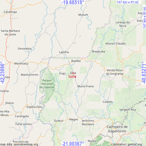
Iúna GPS coordinates[2]
20° 20' 44.988" South, 41° 32' 8.988" West
| Map corner | latitude | longitude |
|---|---|---|
| Upper-left | -19.68518°, | -42.23896° |
| Center: | -20.34583°, | -41.53583° |
| Lower-right: | -21.00367°, | -40.83271° |
| Map W x H: | 146.6×146.6 km | = 91.1×91.1mi |
| max Lat: | 2.81972° ⇑59% North |
| Iúna: | -20.34583° |
| min Lat: | ⇓41% South -33.69111° |
| min Long | Iúna | max Long |
| -72.89583° | -41.53583° | -32.41083° |
| W 67.9%⇐ | ⇒32.1% E |
Elevation
Elevation of Iúna is 670 m = 2198 ft, and this is 289.1 m = 948 ft above average elevation for this country.
| Max E: |
1603 m = 5259 ft | 21.8% |
| Iúna | 670 m 2198 ft | |
| Avg. | 380.9 m = 1250 ft | |
Min E: |
0 m = 0 ft | 78.2% |
See also: Brazil elevation on elevation.city.
Geographical zone
Iúna is located in South Torrid zone (between Equator and Tropic of Capricorn). Distance of this Southern Tropic circle is 343.7 km =213.6 mi to South.| Distance of | km | miles | from Iúna |
|---|---|---|---|
| Equator | 2262.2 | 1405.7 | to North |
| Tropic Capricorn | 343.7 | 213.6 | to South |
| Antarctic Circle | 5138.9 | 3193.2 | to South |
| South Pole | 7744.8 | 4812.4 | to South |


Nearby cities:
15 places around Iúna: (largest is in red/bold)
• Afonso Cláudio
52.5 km =32.6 mi,  54°
54°
• Alegre
46.5 km =28.9 mi,  179°
179°
• Castelo
46.5 km =28.9 mi,  128°
128°
• Conceição do Castelo
30.5 km =19 mi,  94°
94°
• Espera Feliz
51.4 km =31.9 mi,  228°
228°
• Guaçuí
50.1 km =31.1 mi,  197°
197°
• Ibatiba
12.7 km =7.9 mi,  11°
11°
• Irupi
11 km =6.8 mi,  270°
270°
• Jerônimo Monteiro
51.5 km =32 mi,  163°
163°
• Lajinha
23.4 km =14.5 mi,  337°
337°
• Manhuaçu
52.8 km =32.8 mi,  280°
280°
• Manhumirim
44 km =27.3 mi, 268°
• Muniz Freire
18.4 km =11.4 mi,  135°
135°
• Mutum
61.5 km =38.2 mi, 9°
• Vargem Alta
65.9 km =40.9 mi,  123°
123°
Sources, notices
• [Note1] Compared only with cities in Brazil existing in our database
• [Src1] Map data: © OpenStreetMap contributors (CC-BY-SA)
• [Src2] Other city data from geonames.org with taken over terms of usage.
• [Src3] Geographical zone / Annual Mean Temperature by Robert A. Rohde @ Wikipedia
