Guaçuí geodata
Guaçuí (Espírito Santo) is a populated place; located in Brazil in America/Sao_Paulo (GMT-3) time zone. With population of 19,786 people, there are 949 cities with bigger population in this country. Compared to other cities in Brazil, 61.7% of cities are located further ↑North; 67.4% of cities are located further ←West and 72.5% of cities have lower elevation than Guaçuí. Note1


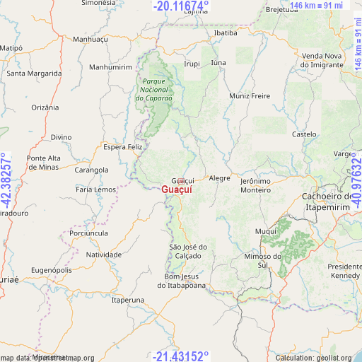
Guaçuí GPS coordinates[2]
20° 46' 32.016" South, 41° 40' 45.984" West
| Map corner | latitude | longitude |
|---|---|---|
| Upper-left | -20.11674°, | -42.38257° |
| Center: | -20.77556°, | -41.67944° |
| Lower-right: | -21.43152°, | -40.97632° |
| Map W x H: | 146.2×146.2 km | = 90.8×90.8mi |
| max Lat: | 2.81972° ⇑61.7% North |
| Guaçuí: | -20.77556° |
| min Lat: | ⇓38.3% South -33.69111° |
| min Long | Guaçuí | max Long |
| -72.89583° | -41.67944° | -32.41083° |
| W 67.4%⇐ | ⇒32.6% E |
Elevation
Elevation of Guaçuí is 597 m = 1959 ft, and this is 216.1 m = 709 ft above average elevation for this country.
| Max E: |
1603 m = 5259 ft | 27.5% |
| Guaçuí | 597 m 1959 ft | |
| Avg. | 380.9 m = 1250 ft | |
Min E: |
0 m = 0 ft | 72.5% |
See also: Brazil elevation on elevation.city.
Geographical zone
Guaçuí is located in South Torrid zone (between Equator and Tropic of Capricorn). Distance of this Southern Tropic circle is 295.9 km =183.9 mi to South.| Distance of | km | miles | from Guaçuí |
|---|---|---|---|
| Equator | 2310 | 1435.4 | to North |
| Tropic Capricorn | 295.9 | 183.9 | to South |
| Antarctic Circle | 5091.1 | 3163.5 | to South |
| South Pole | 7697 | 4782.7 | to South |


Nearby cities:
15 places around Guaçuí: (largest is in red/bold)
• Alegre
15.3 km =9.5 mi,  85°
85°
• Bom Jesus do Itabapoana
39.8 km =24.7 mi,  180°
180°
• Carangola
36.7 km =22.8 mi,  277°
277°
• Castelo
54.9 km =34.1 mi,  69°
69°
• Espera Feliz
27.5 km =17.1 mi,  300°
300°
• Irupi
48 km =29.8 mi,  4°
4°
• Itaperuna
52.4 km =32.6 mi,  204°
204°
• Iúna
50.1 km =31.1 mi,  17°
17°
• Jerônimo Monteiro
29.6 km =18.4 mi, 92°
• Manhumirim
54.8 km =34.1 mi,  328°
328°
• Mimoso do Sul
45.7 km =28.4 mi,  134°
134°
• Muniz Freire
44.4 km =27.6 mi,  38°
38°
• Natividade
42.6 km =26.5 mi,  225°
225°
• Porciúncula
42.9 km =26.7 mi,  240°
240°
• São José do Calçado
27.9 km =17.3 mi,  174°
174°
Sources, notices
• [Note1] Compared only with cities in Brazil existing in our database
• [Src1] Map data: © OpenStreetMap contributors (CC-BY-SA)
• [Src2] Other city data from geonames.org with taken over terms of usage.
• [Src3] Geographical zone / Annual Mean Temperature by Robert A. Rohde @ Wikipedia
