Andradas geodata
Andradas (Minas Gerais) is a populated place; located in Brazil in America/Sao_Paulo (GMT-3) time zone. With population of 26,772 people, there are 739 cities with bigger population in this country. Compared to other cities in Brazil, 70.4% of cities are located further ↑North; 55.4% of cities are located further →East and 95.5% of cities have lower elevation than Andradas. Note1


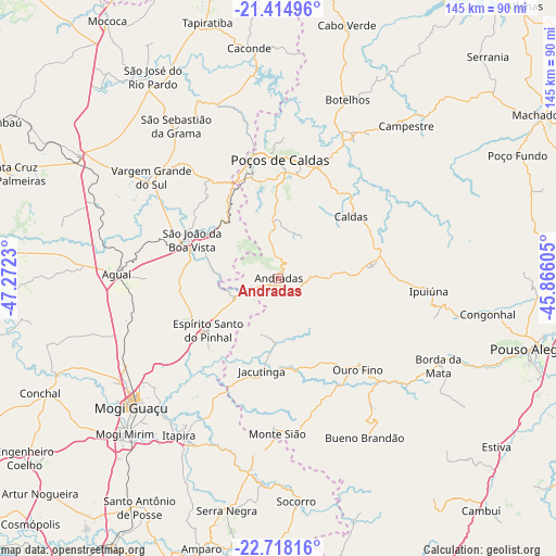
Andradas GPS coordinates[2]
22° 4' 5.016" South, 46° 34' 9.012" West
| Map corner | latitude | longitude |
|---|---|---|
| Upper-left | -21.41496°, | -47.2723° |
| Center: | -22.06806°, | -46.56917° |
| Lower-right: | -22.71816°, | -45.86605° |
| Map W x H: | 144.9×144.9 km | = 90×90mi |
| max Lat: | 2.81972° ⇑70.4% North |
| Andradas: | -22.06806° |
| min Lat: | ⇓29.6% South -33.69111° |
| min Long | Andradas | max Long |
| -72.89583° | -46.56917° | -32.41083° |
| W 44.6%⇐ | ⇒55.4% E |
Elevation
Elevation of Andradas is 905 m = 2969 ft, and this is 524.1 m = 1719 ft above average elevation for this country.
| Max E: |
1603 m = 5259 ft | 4.5% |
| Andradas | 905 m 2969 ft | |
| Avg. | 380.9 m = 1250 ft | |
Min E: |
0 m = 0 ft | 95.5% |
See also: Brazil elevation on elevation.city.
Geographical zone
Andradas is located in South Torrid zone (between Equator and Tropic of Capricorn). Distance of this Southern Tropic circle is 152.2 km =94.6 mi to South.| Distance of | km | miles | from Andradas |
|---|---|---|---|
| Equator | 2453.7 | 1524.7 | to North |
| Tropic Capricorn | 152.2 | 94.6 | to South |
| Antarctic Circle | 4947.4 | 3074.2 | to South |
| South Pole | 7553.3 | 4693.4 | to South |


Nearby cities:
15 places around Andradas: (largest is in red/bold)
• Aguaí
42.2 km =26.2 mi,  271°
271°
• Borda da Mata
47.5 km =29.5 mi,  118°
118°
• Botelhos
51.6 km =32.1 mi,  20°
20°
• Bueno Brandão
47.1 km =29.3 mi,  151°
151°
• Campestre
51.8 km =32.2 mi,  39°
39°
• Espírito Santo do Pinhal
12.9 km =8 mi,  245°
245°
• Itapira
48.5 km =30.1 mi,  212°
212°
• Jacutinga
24.6 km =15.3 mi,  190°
190°
• Mogi Guaçu
51.1 km =31.8 mi,  229°
229°
• Mogi Mirim
56.9 km =35.4 mi,  224°
224°
• Monte Sião
40.5 km =25.2 mi,  180°
180°
• Poços de Caldas
31.2 km =19.4 mi,  1°
1°
• São João da Boa Vista
26 km =16.2 mi,  294°
294°
• Vargem Grande do Sul
42.5 km =26.4 mi,  308°
308°
• Águas de Lindóia
45.9 km =28.5 mi, 188°
Sources, notices
• [Note1] Compared only with cities in Brazil existing in our database
• [Src1] Map data: © OpenStreetMap contributors (CC-BY-SA)
• [Src2] Other city data from geonames.org with taken over terms of usage.
• [Src3] Geographical zone / Annual Mean Temperature by Robert A. Rohde @ Wikipedia
