Adamantina geodata
Adamantina (São Paulo) is a populated place; located in Brazil in America/Sao_Paulo (GMT-3) time zone. With population of 31,078 people, there are 650 cities with bigger population in this country. Compared to other cities in Brazil, 67.8% of cities are located further ↑North; 82.8% of cities are located further →East and 59.6% of cities have lower elevation than Adamantina. Note1


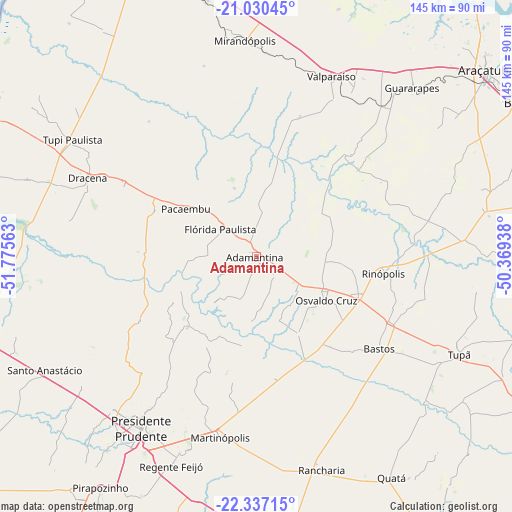
Adamantina GPS coordinates[2]
21° 41' 7.008" South, 51° 4' 21" West
| Map corner | latitude | longitude |
|---|---|---|
| Upper-left | -21.03045°, | -51.77563° |
| Center: | -21.68528°, | -51.0725° |
| Lower-right: | -22.33715°, | -50.36938° |
| Map W x H: | 145.3×145.3 km | = 90.3×90.3mi |
| max Lat: | 2.81972° ⇑67.8% North |
| Adamantina: | -21.68528° |
| min Lat: | ⇓32.2% South -33.69111° |
| min Long | Adamantina | max Long |
| -72.89583° | -51.0725° | -32.41083° |
| W 17.2%⇐ | ⇒82.8% E |
Elevation
Elevation of Adamantina is 468 m = 1535 ft, and this is 87.1 m = 286 ft above average elevation for this country.
| Max E: |
1603 m = 5259 ft | 40.4% |
| Adamantina | 468 m 1535 ft | |
| Avg. | 380.9 m = 1250 ft | |
Min E: |
0 m = 0 ft | 59.6% |
See also: Brazil elevation on elevation.city.
Geographical zone
Adamantina is located in South Torrid zone (between Equator and Tropic of Capricorn). Distance of this Southern Tropic circle is 194.7 km =121 mi to South.| Distance of | km | miles | from Adamantina |
|---|---|---|---|
| Equator | 2411.2 | 1498.2 | to North |
| Tropic Capricorn | 194.7 | 121 | to South |
| Antarctic Circle | 4990 | 3100.6 | to South |
| South Pole | 7595.9 | 4719.9 | to South |


Nearby cities:
15 places around Adamantina: (largest is in red/bold)
• Bastos
43.8 km =27.2 mi,  126°
126°
• Junqueirópolis
41.9 km =26 mi,  296°
296°
• Lucélia
6.8 km =4.2 mi, 125°
• Martinópolis
52.2 km =32.4 mi,  191°
191°
• Mirandopólis
61.4 km =38.2 mi,  357°
357°
• Osvaldo Cruz
23.5 km =14.6 mi,  121°
121°
• Pacaembu
23.8 km =14.8 mi,  305°
305°
• Paulista Flórida
16.2 km =10.1 mi, 305°
• Presidente Bernardes
61.1 km =38 mi,  234°
234°
• Presidente Prudente
58.8 km =36.5 mi,  213°
213°
• Rancharia
63.2 km =39.3 mi,  162°
162°
• Santo Anastácio
58.1 km =36.1 mi,  252°
252°
• Tupi Paulista
61.6 km =38.3 mi, 303°
• Valparaíso
55.1 km =34.2 mi,  22°
22°
• Álvares Machado
60.2 km =37.4 mi,  223°
223°
Sources, notices
• [Note1] Compared only with cities in Brazil existing in our database
• [Src1] Map data: © OpenStreetMap contributors (CC-BY-SA)
• [Src2] Other city data from geonames.org with taken over terms of usage.
• [Src3] Geographical zone / Annual Mean Temperature by Robert A. Rohde @ Wikipedia
