Lucélia geodata
Lucélia (São Paulo) is a populated place; located in Brazil in America/Sao_Paulo (GMT-3) time zone. With population of 14,806 people, there are 1227 cities with bigger population in this country. Compared to other cities in Brazil, 68.1% of cities are located further ↑North; 82.5% of cities are located further →East and 58.1% of cities have lower elevation than Lucélia. Note1


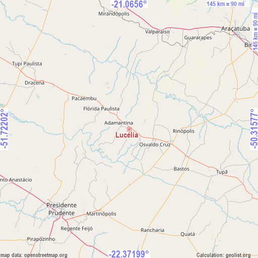
Lucélia GPS coordinates[2]
21° 43' 13.008" South, 51° 1' 8.004" West
| Map corner | latitude | longitude |
|---|---|---|
| Upper-left | -21.0656°, | -51.72202° |
| Center: | -21.72028°, | -51.01889° |
| Lower-right: | -22.37199°, | -50.31577° |
| Map W x H: | 145.3×145.3 km | = 90.3×90.3mi |
| max Lat: | 2.81972° ⇑68.1% North |
| Lucélia: | -21.72028° |
| min Lat: | ⇓31.9% South -33.69111° |
| min Long | Lucélia | max Long |
| -72.89583° | -51.01889° | -32.41083° |
| W 17.5%⇐ | ⇒82.5% E |
Elevation
Elevation of Lucélia is 453 m = 1486 ft, and this is 72.1 m = 237 ft above average elevation for this country.
| Max E: |
1603 m = 5259 ft | 41.9% |
| Lucélia | 453 m 1486 ft | |
| Avg. | 380.9 m = 1250 ft | |
Min E: |
0 m = 0 ft | 58.1% |
See also: Brazil elevation on elevation.city.
Geographical zone
Lucélia is located in South Torrid zone (between Equator and Tropic of Capricorn). Distance of this Southern Tropic circle is 190.9 km =118.6 mi to South.| Distance of | km | miles | from Lucélia |
|---|---|---|---|
| Equator | 2415.1 | 1500.7 | to North |
| Tropic Capricorn | 190.9 | 118.6 | to South |
| Antarctic Circle | 4986.1 | 3098.2 | to South |
| South Pole | 7592 | 4717.4 | to South |


Nearby cities:
15 places around Lucélia: (largest is in red/bold)
• Adamantina
6.8 km =4.2 mi,  305°
305°
• Bastos
37 km =23 mi,  127°
127°
• Junqueirópolis
48.6 km =30.2 mi,  298°
298°
• Martinópolis
49.8 km =30.9 mi,  198°
198°
• Osvaldo Cruz
16.8 km =10.4 mi,  120°
120°
• Pacaembu
30.5 km =19 mi, 305°
• Paulista Flórida
23 km =14.3 mi, 305°
• Presidente Bernardes
63.6 km =39.5 mi,  240°
240°
• Presidente Prudente
59.1 km =36.7 mi,  220°
220°
• Rancharia
58.1 km =36.1 mi,  167°
167°
• Regente Feijó
62.9 km =39.1 mi,  207°
207°
• Santo Anastácio
62.5 km =38.8 mi,  257°
257°
• Tupã
57.3 km =35.6 mi,  114°
114°
• Valparaíso
56.9 km =35.4 mi,  15°
15°
• Álvares Machado
61.5 km =38.2 mi,  229°
229°
Sources, notices
• [Note1] Compared only with cities in Brazil existing in our database
• [Src1] Map data: © OpenStreetMap contributors (CC-BY-SA)
• [Src2] Other city data from geonames.org with taken over terms of usage.
• [Src3] Geographical zone / Annual Mean Temperature by Robert A. Rohde @ Wikipedia
