Bastos geodata
Bastos (São Paulo) is a populated place; located in Brazil in America/Sao_Paulo (GMT-3) time zone. With population of 17,680 people, there are 1055 cities with bigger population in this country. Compared to other cities in Brazil, 69.5% of cities are located further ↑North; 81.4% of cities are located further →East and 58.6% of cities have lower elevation than Bastos. Note1


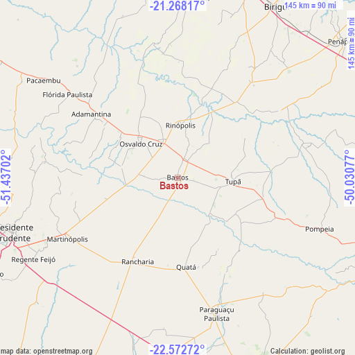
Bastos GPS coordinates[2]
21° 55' 18.984" South, 50° 44' 2.004" West
| Map corner | latitude | longitude |
|---|---|---|
| Upper-left | -21.26817°, | -51.43702° |
| Center: | -21.92194°, | -50.73389° |
| Lower-right: | -22.57272°, | -50.03077° |
| Map W x H: | 145.1×145.1 km | = 90.2×90.2mi |
| max Lat: | 2.81972° ⇑69.5% North |
| Bastos: | -21.92194° |
| min Lat: | ⇓30.5% South -33.69111° |
| min Long | Bastos | max Long |
| -72.89583° | -50.73389° | -32.41083° |
| W 18.6%⇐ | ⇒81.4% E |
Elevation
Elevation of Bastos is 460 m = 1509 ft, and this is 79.1 m = 260 ft above average elevation for this country.
| Max E: |
1603 m = 5259 ft | 41.4% |
| Bastos | 460 m 1509 ft | |
| Avg. | 380.9 m = 1250 ft | |
Min E: |
0 m = 0 ft | 58.6% |
See also: Brazil elevation on elevation.city.
Geographical zone
Bastos is located in South Torrid zone (between Equator and Tropic of Capricorn). Distance of this Southern Tropic circle is 168.4 km =104.6 mi to South.| Distance of | km | miles | from Bastos |
|---|---|---|---|
| Equator | 2437.5 | 1514.6 | to North |
| Tropic Capricorn | 168.4 | 104.6 | to South |
| Antarctic Circle | 4963.7 | 3084.3 | to South |
| South Pole | 7569.6 | 4703.5 | to South |


Nearby cities:
15 places around Bastos: (largest is in red/bold)
• Adamantina
43.8 km =27.2 mi,  306°
306°
• Guararapes
74.1 km =46 mi,  7°
7°
• Lucélia
37 km =23 mi, 307°
• Maracaí
76.9 km =47.8 mi,  174°
174°
• Martinópolis
51.5 km =32 mi,  241°
241°
• Osvaldo Cruz
20.4 km =12.7 mi, 313°
• Pacaembu
67.5 km =41.9 mi, 306°
• Paraguaçu Paulista
57 km =35.4 mi,  163°
163°
• Paulista Flórida
60 km =37.3 mi, 306°
• Pompéia
61.6 km =38.3 mi,  109°
109°
• Presidente Prudente
71.2 km =44.2 mi,  251°
251°
• Quatá
36.4 km =22.6 mi, 174°
• Rancharia
37.9 km =23.5 mi,  205°
205°
• Regente Feijó
67.4 km =41.9 mi, 240°
• Tupã
22.8 km =14.2 mi,  93°
93°
Sources, notices
• [Note1] Compared only with cities in Brazil existing in our database
• [Src1] Map data: © OpenStreetMap contributors (CC-BY-SA)
• [Src2] Other city data from geonames.org with taken over terms of usage.
• [Src3] Geographical zone / Annual Mean Temperature by Robert A. Rohde @ Wikipedia
