Osvaldo Cruz geodata
Osvaldo Cruz (São Paulo) is a populated place; located in Brazil in America/Sao_Paulo (GMT-3) time zone. With population of 25,746 people, there are 765 cities with bigger population in this country. Compared to other cities in Brazil, 68.6% of cities are located further ↑North; 81.9% of cities are located further →East and 59.2% of cities have lower elevation than Osvaldo Cruz. Note1


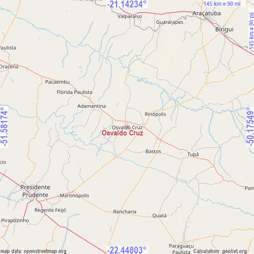
Osvaldo Cruz GPS coordinates[2]
21° 47' 48.012" South, 50° 52' 42.996" West
| Map corner | latitude | longitude |
|---|---|---|
| Upper-left | -21.14234°, | -51.58174° |
| Center: | -21.79667°, | -50.87861° |
| Lower-right: | -22.44803°, | -50.17549° |
| Map W x H: | 145.2×145.2 km | = 90.2×90.2mi |
| max Lat: | 2.81972° ⇑68.6% North |
| Osvaldo Cruz: | -21.79667° |
| min Lat: | ⇓31.4% South -33.69111° |
| min Long | Osvaldo Cruz | max Long |
| -72.89583° | -50.87861° | -32.41083° |
| W 18.1%⇐ | ⇒81.9% E |
Elevation
Elevation of Osvaldo Cruz is 465 m = 1526 ft, and this is 84.1 m = 276 ft above average elevation for this country.
| Max E: |
1603 m = 5259 ft | 40.8% |
| Osvaldo Cruz | 465 m 1526 ft | |
| Avg. | 380.9 m = 1250 ft | |
Min E: |
0 m = 0 ft | 59.2% |
See also: Brazil elevation on elevation.city.
Geographical zone
Osvaldo Cruz is located in South Torrid zone (between Equator and Tropic of Capricorn). Distance of this Southern Tropic circle is 182.4 km =113.3 mi to South.| Distance of | km | miles | from Osvaldo Cruz |
|---|---|---|---|
| Equator | 2423.6 | 1506 | to North |
| Tropic Capricorn | 182.4 | 113.3 | to South |
| Antarctic Circle | 4977.6 | 3092.9 | to South |
| South Pole | 7583.5 | 4712.2 | to South |


Nearby cities:
15 places around Osvaldo Cruz: (largest is in red/bold)
• Adamantina
23.5 km =14.6 mi,  301°
301°
• Bastos
20.4 km =12.7 mi,  133°
133°
• Guararapes
64.4 km =40 mi,  22°
22°
• Junqueirópolis
65.4 km =40.6 mi, 298°
• Lucélia
16.8 km =10.4 mi, 300°
• Martinópolis
49.1 km =30.5 mi,  217°
217°
• Pacaembu
47.3 km =29.4 mi, 303°
• Paulista Flórida
39.8 km =24.7 mi, 303°
• Presidente Prudente
64.1 km =39.8 mi,  235°
235°
• Quatá
53.5 km =33.2 mi,  159°
159°
• Rancharia
48.1 km =29.9 mi,  181°
181°
• Regente Feijó
64.4 km =40 mi, 222°
• Tupã
40.7 km =25.3 mi,  112°
112°
• Valparaíso
63.3 km =39.3 mi,  0°
0°
• Álvares Machado
68.8 km =42.8 mi, 242°
Sources, notices
• [Note1] Compared only with cities in Brazil existing in our database
• [Src1] Map data: © OpenStreetMap contributors (CC-BY-SA)
• [Src2] Other city data from geonames.org with taken over terms of usage.
• [Src3] Geographical zone / Annual Mean Temperature by Robert A. Rohde @ Wikipedia
