Ibirama geodata
Ibirama (Santa Catarina) is a populated place; located in Brazil in America/Sao_Paulo (GMT-3) time zone. With population of 18,357 people, there are 1020 cities with bigger population in this country. Compared to other cities in Brazil, 91.4% of cities are located further ↑North; 75.8% of cities are located further →East and 66.4% of cities have higher elevation than Ibirama. Note1


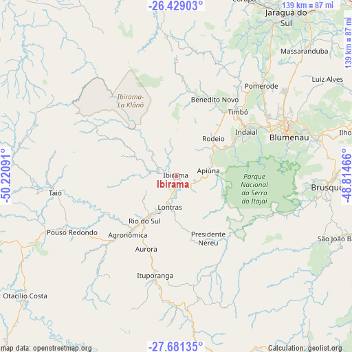
Ibirama GPS coordinates[2]
27° 3' 24.984" South, 49° 31' 4.008" West
| Map corner | latitude | longitude |
|---|---|---|
| Upper-left | -26.42903°, | -50.22091° |
| Center: | -27.05694°, | -49.51778° |
| Lower-right: | -27.68135°, | -48.81466° |
| Map W x H: | 139.2×139.2 km | = 86.5×86.5mi |
| max Lat: | 2.81972° ⇑91.4% North |
| Ibirama: | -27.05694° |
| min Lat: | ⇓8.6% South -33.69111° |
| min Long | Ibirama | max Long |
| -72.89583° | -49.51778° | -32.41083° |
| W 24.2%⇐ | ⇒75.8% E |
Elevation
Elevation of Ibirama is 156 m = 512 ft, and this is 224.9 m = 738 ft below average elevation for this country.
| Max E: |
1603 m = 5259 ft | 66.4% |
| Avg. | 380.9 m = 1250 ft | |
| Ibirama | 156 m = 512 ft | |
Min E: |
0 m = 0 ft | 33.6% |
See also: Brazil elevation on elevation.city.
Geographical zone
Ibirama is located in South temperate zone (between Tropic of Capricorn and the Antarctic Circle). Distance of this Southern Tropic circle is 402.5 km =250.1 mi to North.| Distance of | km | miles | from Ibirama |
|---|---|---|---|
| Equator | 3008.4 | 1869.3 | to North |
| Tropic Capricorn | 402.5 | 250.1 | to North |
| Antarctic Circle | 4392.7 | 2729.5 | to South |
| South Pole | 6998.6 | 4348.7 | to South |


Nearby cities:
15 places around Ibirama: (largest is in red/bold)
• Blumenau
47.3 km =29.4 mi,  71°
71°
• Brusque
60.1 km =37.3 mi,  94°
94°
• Corupá
75.3 km =46.8 mi,  21°
21°
• Gaspar
57.1 km =35.5 mi,  75°
75°
• Guaramirim
82.6 km =51.3 mi,  38°
38°
• Indaial
33.4 km =20.8 mi,  58°
58°
• Jaraguá do Sul
77.7 km =48.3 mi, 35°
• Otacílio Costa
76.2 km =47.3 mi,  231°
231°
• Pomerode
48.8 km =30.3 mi, 43°
• Residencia Moacir PU5BHV
22.3 km =13.9 mi, 42°
• Rio do Sul
21.4 km =13.3 mi,  215°
215°
• Rodeio
21.2 km =13.2 mi,  45°
45°
• Schroeder
84.2 km =52.3 mi,  31°
31°
• São João Batista
70.5 km =43.8 mi,  110°
110°
• Timbó
35.6 km =22.1 mi, 43°
Sources, notices
• [Note1] Compared only with cities in Brazil existing in our database
• [Src1] Map data: © OpenStreetMap contributors (CC-BY-SA)
• [Src2] Other city data from geonames.org with taken over terms of usage.
• [Src3] Geographical zone / Annual Mean Temperature by Robert A. Rohde @ Wikipedia
