Corupá geodata
Corupá (Santa Catarina) is a populated place; located in Brazil in America/Sao_Paulo (GMT-3) time zone. With population of 12,600 people, there are 1411 cities with bigger population in this country. Compared to other cities in Brazil, 90.4% of cities are located further ↑North; 73.5% of cities are located further →East and 76.8% of cities have higher elevation than Corupá. Note1


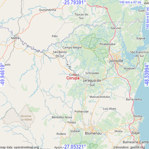
Corupá GPS coordinates[2]
26° 25' 31.008" South, 49° 14' 35.016" West
| Map corner | latitude | longitude |
|---|---|---|
| Upper-left | -25.79391°, | -49.94619° |
| Center: | -26.42528°, | -49.24306° |
| Lower-right: | -27.05321°, | -48.53994° |
| Map W x H: | 140×140 km | = 87×87mi |
| max Lat: | 2.81972° ⇑90.4% North |
| Corupá: | -26.42528° |
| min Lat: | ⇓9.6% South -33.69111° |
| min Long | Corupá | max Long |
| -72.89583° | -49.24306° | -32.41083° |
| W 26.5%⇐ | ⇒73.5% E |
Elevation
Elevation of Corupá is 66 m = 217 ft, and this is 314.9 m = 1033 ft below average elevation for this country.
| Max E: |
1603 m = 5259 ft | 76.8% |
| Avg. | 380.9 m = 1250 ft | |
| Corupá | 66 m = 217 ft | |
Min E: |
0 m = 0 ft | 23.2% |
See also: Brazil elevation on elevation.city.
Geographical zone
Corupá is located in South temperate zone (between Tropic of Capricorn and the Antarctic Circle). Distance of this Southern Tropic circle is 332.3 km =206.5 mi to North.| Distance of | km | miles | from Corupá |
|---|---|---|---|
| Equator | 2938.2 | 1825.7 | to North |
| Tropic Capricorn | 332.3 | 206.5 | to North |
| Antarctic Circle | 4463 | 2773.2 | to South |
| South Pole | 7068.8 | 4392.3 | to South |


Nearby cities:
15 places around Corupá: (largest is in red/bold)
• Barra Velha
60.1 km =37.3 mi,  112°
112°
• Blumenau
57.7 km =35.9 mi,  162°
162°
• Gaspar
63 km =39.1 mi,  153°
153°
• Guaramirim
24.5 km =15.2 mi,  102°
102°
• Indaial
52.5 km =32.6 mi,  178°
178°
• Jaraguá do Sul
18.8 km =11.7 mi, 111°
• Joinville
41.8 km =26 mi,  71°
71°
• Pomerode
35.7 km =22.2 mi,  169°
169°
• Residencia Moacir PU5BHV
55.2 km =34.3 mi,  192°
192°
• Rio Negrinho
33.4 km =20.8 mi,  304°
304°
• Rodeio
56.7 km =35.2 mi, 192°
• Schroeder
17 km =10.6 mi,  85°
85°
• São Bento do Sul
23.7 km =14.7 mi,  325°
325°
• São Francisco do Sul
63.6 km =39.5 mi, 71°
• Timbó
44.4 km =27.6 mi, 183°
Sources, notices
• [Note1] Compared only with cities in Brazil existing in our database
• [Src1] Map data: © OpenStreetMap contributors (CC-BY-SA)
• [Src2] Other city data from geonames.org with taken over terms of usage.
• [Src3] Geographical zone / Annual Mean Temperature by Robert A. Rohde @ Wikipedia
