Serowe geodata
Serowe (Central) is a seat of a first-order administrative division; located in Botswana in Africa/Gaborone (GMT+2) time zone. With population of 47,419 people, there are 5 cities with bigger population in this country. Compared to other cities in Botswana, 66.7% of cities are located further ↓South; 68.6% of cities are located further ←West and 87.6% of cities have lower elevation than Serowe. Note1


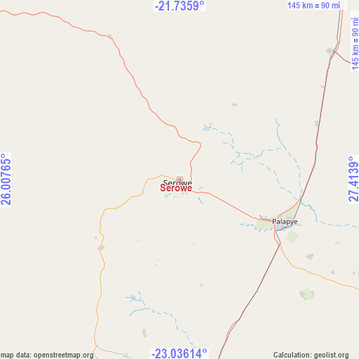
Serowe GPS coordinates[2]
22° 23' 15.144" South, 26° 42' 38.772" East
| Map corner | latitude | longitude |
|---|---|---|
| Upper-left | -21.7359°, | 26.00765° |
| Center: | -22.38754°, | 26.71077° |
| Lower-right: | -23.03614°, | 27.4139° |
| Map W x H: | 144.6×144.6 km | = 89.9×89.9mi |
| max Lat: | -17.80165° ⇑33.3% North |
| Serowe: | -22.38754° |
| min Lat: | ⇓66.7% South -26.9° |
| min Long | Serowe | max Long |
| 20.06667° | 26.71077° | 28.74946° |
| W 68.6%⇐ | ⇒31.4% E |
Elevation
Elevation of Serowe is 1147 m = 3763 ft, and this is 132 m = 433 ft above average elevation for this country.
| Max E: |
1406 m = 4613 ft | 12.4% |
| Serowe | 1147 m 3763 ft | |
| Avg. | 1015 m = 3330 ft | |
Min E: |
676 m = 2218 ft | 87.6% |
See also: Serowe elevation on elevation.city.
Geographical zone
Serowe is located in South Torrid zone (between Equator and Tropic of Capricorn). Distance of this Southern Tropic circle is 116.7 km =72.5 mi to South.| Distance of | km | miles | from Serowe |
|---|---|---|---|
| Equator | 2489.3 | 1546.8 | to North |
| Tropic Capricorn | 116.7 | 72.5 | to South |
| Antarctic Circle | 4911.9 | 3052.1 | to South |
| South Pole | 7517.8 | 4671.3 | to South |


Nearby cities:
15 places around Serowe: (largest is in red/bold)
• Bonwapitse
72.8 km =45.2 mi,  185°
185°
• Kalamare
62.4 km =38.8 mi, 193°
• Letsheng
61 km =37.9 mi,  120°
120°
• Maapi
77.5 km =48.2 mi, 122°
• Mahalapye
80.4 km =50 mi,  172°
172°
• Malaka
68.4 km =42.5 mi,  111°
111°
• Mathakola
71.9 km =44.7 mi, 121°
• Mogapinyana
91.5 km =56.9 mi,  88°
88°
• Moijabana
30.7 km =19.1 mi,  260°
260°
• Moremi
78.7 km =48.9 mi, 105°
• Palapye
46.1 km =28.6 mi, 112°
• Pilikwe
67.5 km =41.9 mi,  132°
132°
• Ramokgonami
90.4 km =56.2 mi, 125°
• Shakgwe
91.9 km =57.1 mi,  150°
150°
• Tamasane
71.1 km =44.2 mi, 92°
Sources, notices
• [Note1] Compared only with cities in Botswana existing in our database
• [Src1] Map data: © OpenStreetMap contributors (CC-BY-SA)
• [Src2] Other city data from geonames.org with taken over terms of usage.
• [Src3] Geographical zone / Annual Mean Temperature by Robert A. Rohde @ Wikipedia
