Mogapinyana geodata
Mogapinyana is a populated place; located in Botswana in Africa/Gaborone (GMT+2) time zone. With population of 1,515 people, there are 70 cities with bigger population in this country. Compared to other cities in Botswana, 67.6% of cities are located further ↓South; 92.4% of cities are located further ←West and 82.9% of cities have higher elevation than Mogapinyana. Note1


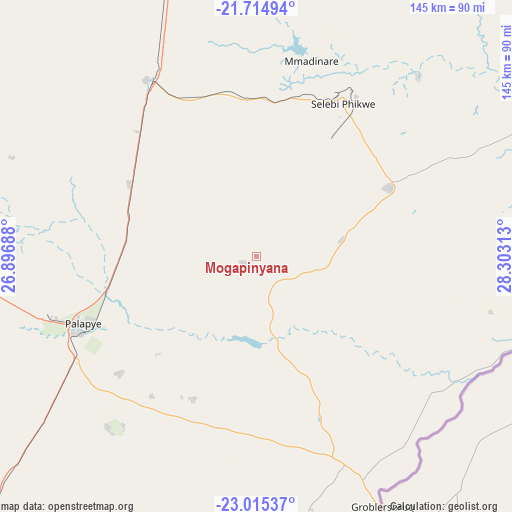
Mogapinyana GPS coordinates[2]
22° 22' 0.012" South, 27° 36' 0" East
| Map corner | latitude | longitude |
|---|---|---|
| Upper-left | -21.71494°, | 26.89688° |
| Center: | -22.36667°, | 27.6° |
| Lower-right: | -23.01537°, | 28.30313° |
| Map W x H: | 144.6×144.6 km | = 89.9×89.9mi |
| max Lat: | -17.80165° ⇑32.4% North |
| Mogapinyana: | -22.36667° |
| min Lat: | ⇓67.6% South -26.9° |
| min Long | Mogapinyana | max Long |
| 20.06667° | 27.6° | 28.74946° |
| W 92.4%⇐ | ⇒7.6% E |
Elevation
Elevation of Mogapinyana is 915 m = 3002 ft, and this is 100 m = 328 ft below average elevation for this country.
| Max E: |
1406 m = 4613 ft | 82.9% |
| Avg. | 1015 m = 3330 ft | |
| Mogapinyana | 915 m = 3002 ft | |
Min E: |
676 m = 2218 ft | 17.1% |
See also: Botswana elevation on elevation.city.
Geographical zone
Mogapinyana is located in South Torrid zone (between Equator and Tropic of Capricorn). Distance of this Southern Tropic circle is 119 km =73.9 mi to South.| Distance of | km | miles | from Mogapinyana |
|---|---|---|---|
| Equator | 2486.9 | 1545.3 | to North |
| Tropic Capricorn | 119 | 73.9 | to South |
| Antarctic Circle | 4914.2 | 3053.5 | to South |
| South Pole | 7520.1 | 4672.8 | to South |


Nearby cities:
15 places around Mogapinyana: (largest is in red/bold)
• Letsheng
50.8 km =31.6 mi,  229°
229°
• Maapi
50.5 km =31.4 mi,  210°
210°
• Malaka
39.2 km =24.4 mi, 225°
• Mathakola
49.4 km =30.7 mi,  217°
217°
• Maunatlala
25.8 km =16 mi,  173°
173°
• Mogapi
24.6 km =15.3 mi,  78°
78°
• Moremi
27.5 km =17.1 mi, 213°
• Palapye
52.7 km =32.7 mi,  247°
247°
• Pilikwe
63.6 km =39.5 mi, 220°
• Ramokgonami
58.2 km =36.2 mi,  198°
198°
• Ratholo
39.9 km =24.8 mi,  184°
184°
• Sefophe
42.9 km =26.7 mi,  61°
61°
• Selebi-Phikwe
49.8 km =30.9 mi,  30°
30°
• Tamasane
21.2 km =13.2 mi, 254°
• Tobane
55.7 km =34.6 mi, 33°
Sources, notices
• [Note1] Compared only with cities in Botswana existing in our database
• [Src1] Map data: © OpenStreetMap contributors (CC-BY-SA)
• [Src2] Other city data from geonames.org with taken over terms of usage.
• [Src3] Geographical zone / Annual Mean Temperature by Robert A. Rohde @ Wikipedia
