Moijabana geodata
Moijabana (Central) is a populated place; located in Botswana in Africa/Gaborone (GMT+2) time zone. With population of 2,768 people, there are 45 cities with bigger population in this country. Compared to other cities in Botswana, 64.8% of cities are located further ↓South; 61.9% of cities are located further ←West and 95.2% of cities have lower elevation than Moijabana. Note1


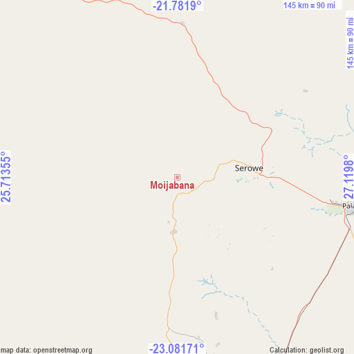
Moijabana GPS coordinates[2]
22° 25' 59.988" South, 26° 25' 0.012" East
| Map corner | latitude | longitude |
|---|---|---|
| Upper-left | -21.7819°, | 25.71355° |
| Center: | -22.43333°, | 26.41667° |
| Lower-right: | -23.08171°, | 27.1198° |
| Map W x H: | 144.5×144.5 km | = 89.8×89.8mi |
| max Lat: | -17.80165° ⇑35.2% North |
| Moijabana: | -22.43333° |
| min Lat: | ⇓64.8% South -26.9° |
| min Long | Moijabana | max Long |
| 20.06667° | 26.41667° | 28.74946° |
| W 61.9%⇐ | ⇒38.1% E |
Elevation
Elevation of Moijabana is 1214 m = 3983 ft, and this is 199 m = 653 ft above average elevation for this country.
| Max E: |
1406 m = 4613 ft | 4.8% |
| Moijabana | 1214 m 3983 ft | |
| Avg. | 1015 m = 3330 ft | |
Min E: |
676 m = 2218 ft | 95.2% |
See also: Botswana elevation on elevation.city.
Geographical zone
Moijabana is located in South Torrid zone (between Equator and Tropic of Capricorn). Distance of this Southern Tropic circle is 111.6 km =69.3 mi to South.| Distance of | km | miles | from Moijabana |
|---|---|---|---|
| Equator | 2494.4 | 1549.9 | to North |
| Tropic Capricorn | 111.6 | 69.3 | to South |
| Antarctic Circle | 4906.8 | 3048.9 | to South |
| South Pole | 7512.7 | 4668.2 | to South |


Nearby cities:
15 places around Moijabana: (largest is in red/bold)
• Bonwapitse
71.1 km =44.2 mi,  161°
161°
• Kalamare
57.8 km =35.9 mi, 164°
• Letsheng
86.8 km =53.9 mi,  107°
107°
• Maapi
102.4 km =63.6 mi, 110°
• Mahalapye
85 km =52.8 mi,  151°
151°
• Malaka
95.9 km =59.6 mi,  102°
102°
• Mathakola
97.2 km =60.4 mi, 109°
• Mogapinyana
121.9 km =75.7 mi,  86°
86°
• Moremi
107.3 km =66.7 mi, 98°
• Palapye
73.8 km =45.9 mi, 99°
• Pilikwe
89.5 km =55.6 mi,  117°
117°
• Ramokgonami
113.9 km =70.8 mi, 114°
• Serowe
30.7 km =19.1 mi,  80°
80°
• Shakgwe
106.3 km =66.1 mi,  134°
134°
• Tamasane
101.2 km =62.9 mi, 89°
Sources, notices
• [Note1] Compared only with cities in Botswana existing in our database
• [Src1] Map data: © OpenStreetMap contributors (CC-BY-SA)
• [Src2] Other city data from geonames.org with taken over terms of usage.
• [Src3] Geographical zone / Annual Mean Temperature by Robert A. Rohde @ Wikipedia
