Kalamare geodata
Kalamare (Central) is a populated place; located in Botswana in Africa/Gaborone (GMT+2) time zone. With population of 2,339 people, there are 49 cities with bigger population in this country. Compared to other cities in Botswana, 54.3% of cities are located further ↓South; 64.8% of cities are located further ←West and 90.5% of cities have lower elevation than Kalamare. Note1


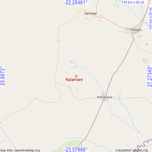
Kalamare GPS coordinates[2]
22° 56' 1.284" South, 26° 34' 13.152" East
| Map corner | latitude | longitude |
|---|---|---|
| Upper-left | -22.28461°, | 25.8672° |
| Center: | -22.93369°, | 26.57032° |
| Lower-right: | -23.57968°, | 27.27345° |
| Map W x H: | 144×144 km | = 89.5×89.5mi |
| max Lat: | -17.80165° ⇑45.7% North |
| Kalamare: | -22.93369° |
| min Lat: | ⇓54.3% South -26.9° |
| min Long | Kalamare | max Long |
| 20.06667° | 26.57032° | 28.74946° |
| W 64.8%⇐ | ⇒35.2% E |
Elevation
Elevation of Kalamare is 1182 m = 3878 ft, and this is 167 m = 548 ft above average elevation for this country.
| Max E: |
1406 m = 4613 ft | 9.5% |
| Kalamare | 1182 m 3878 ft | |
| Avg. | 1015 m = 3330 ft | |
Min E: |
676 m = 2218 ft | 90.5% |
See also: Botswana elevation on elevation.city.
Geographical zone
Kalamare is located in South Torrid zone (between Equator and Tropic of Capricorn). Distance of this Southern Tropic circle is 55.9 km =34.7 mi to South.| Distance of | km | miles | from Kalamare |
|---|---|---|---|
| Equator | 2550 | 1584.5 | to North |
| Tropic Capricorn | 55.9 | 34.7 | to South |
| Antarctic Circle | 4851.2 | 3014.4 | to South |
| South Pole | 7457.1 | 4633.6 | to South |


Nearby cities:
15 places around Kalamare: (largest is in red/bold)
• Bonwapitse
13.6 km =8.5 mi,  149°
149°
• Kurametsi
72.5 km =45 mi,  135°
135°
• Letsheng
73.4 km =45.6 mi,  65°
65°
• Maapi
82.3 km =51.1 mi,  76°
76°
• Magothla
82.9 km =51.5 mi, 148°
• Mahalapye
31.3 km =19.4 mi,  127°
127°
• Makoba
82.8 km =51.4 mi, 137°
• Makwata
84.1 km =52.3 mi,  117°
117°
• Mathakola
79.5 km =49.4 mi, 72°
• Moijabana
57.8 km =35.9 mi,  344°
344°
• Mookane
84.4 km =52.4 mi,  173°
173°
• Palapye
71.4 km =44.4 mi,  52°
52°
• Pilikwe
65.6 km =40.8 mi, 76°
• Serowe
62.4 km =38.8 mi,  13°
13°
• Shakgwe
62.6 km =38.9 mi,  107°
107°
Sources, notices
• [Note1] Compared only with cities in Botswana existing in our database
• [Src1] Map data: © OpenStreetMap contributors (CC-BY-SA)
• [Src2] Other city data from geonames.org with taken over terms of usage.
• [Src3] Geographical zone / Annual Mean Temperature by Robert A. Rohde @ Wikipedia
