Mosopa geodata
Mosopa (Ngwaketsi) is a populated place; located in Botswana in Africa/Gaborone (GMT+2) time zone. With population of 19,561 people, there are 14 cities with bigger population in this country. Compared to other cities in Botswana, 89.5% of cities are located further ↑North; 67.6% of cities are located further →East and 81.9% of cities have lower elevation than Mosopa. Note1


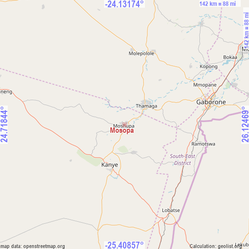
Mosopa GPS coordinates[2]
24° 46' 18.48" South, 25° 25' 17.616" East
| Map corner | latitude | longitude |
|---|---|---|
| Upper-left | -24.13174°, | 24.71844° |
| Center: | -24.7718°, | 25.42156° |
| Lower-right: | -25.40857°, | 26.12469° |
| Map W x H: | 142×142 km | = 88.2×88.2mi |
| max Lat: | -17.80165° ⇑89.5% North |
| Mosopa: | -24.7718° |
| min Lat: | ⇓10.5% South -26.9° |
| min Long | Mosopa | max Long |
| 20.06667° | 25.42156° | 28.74946° |
| W 32.4%⇐ | ⇒67.6% E |
Elevation
Elevation of Mosopa is 1136 m = 3727 ft, and this is 121 m = 397 ft above average elevation for this country.
| Max E: |
1406 m = 4613 ft | 18.1% |
| Mosopa | 1136 m 3727 ft | |
| Avg. | 1015 m = 3330 ft | |
Min E: |
676 m = 2218 ft | 81.9% |
See also: Botswana elevation on elevation.city.
Geographical zone
Mosopa is located in South temperate zone (between Tropic of Capricorn and the Antarctic Circle). Distance of this Southern Tropic circle is 148.4 km =92.2 mi to North.| Distance of | km | miles | from Mosopa |
|---|---|---|---|
| Equator | 2754.4 | 1711.5 | to North |
| Tropic Capricorn | 148.4 | 92.2 | to North |
| Antarctic Circle | 4646.8 | 2887.4 | to South |
| South Pole | 7252.7 | 4506.6 | to South |


Nearby cities:
15 places around Mosopa: (largest is in red/bold)
• Dumadumana
50.1 km =31.1 mi,  65°
65°
• Gabane
38.3 km =23.8 mi, 72°
• Gaborone
50.9 km =31.6 mi,  75°
75°
• Galekgatshwane
48.1 km =29.9 mi,  54°
54°
• Gaphatshwe
47.1 km =29.3 mi,  62°
62°
• Kanye
23.5 km =14.6 mi,  202°
202°
• Metsemotlhaba
45.7 km =28.4 mi, 57°
• Mmokolodi
39.2 km =24.4 mi, 77°
• Mogoditshane
47.7 km =29.6 mi, 70°
• Molepolole
41.3 km =25.7 mi,  10°
10°
• Mononyane
43.6 km =27.1 mi, 54°
• Nkoyaphiri
44.2 km =27.5 mi, 69°
• Otse
41.6 km =25.8 mi,  130°
130°
• Ramotswa
46.6 km =29 mi,  103°
103°
• Thamaga
16.4 km =10.2 mi, 46°
Sources, notices
• [Note1] Compared only with cities in Botswana existing in our database
• [Src1] Map data: © OpenStreetMap contributors (CC-BY-SA)
• [Src2] Other city data from geonames.org with taken over terms of usage.
• [Src3] Geographical zone / Annual Mean Temperature by Robert A. Rohde @ Wikipedia
