Molepolole geodata
Molepolole (Kweneng) is a seat of a first-order administrative division; located in Botswana in Africa/Gaborone (GMT+2) time zone. With population of 63,248 people, there are 2 cities with bigger population in this country. Compared to other cities in Botswana, 69.5% of cities are located further ↑North; 65.7% of cities are located further →East and 86.7% of cities have lower elevation than Molepolole. Note1


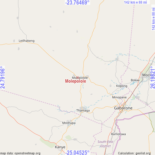
Molepolole GPS coordinates[2]
24° 24' 23.724" South, 25° 29' 42.288" East
| Map corner | latitude | longitude |
|---|---|---|
| Upper-left | -23.76469°, | 24.79196° |
| Center: | -24.40659°, | 25.49508° |
| Lower-right: | -25.04525°, | 26.19821° |
| Map W x H: | 142.4×142.4 km | = 88.5×88.5mi |
| max Lat: | -17.80165° ⇑69.5% North |
| Molepolole: | -24.40659° |
| min Lat: | ⇓30.5% South -26.9° |
| min Long | Molepolole | max Long |
| 20.06667° | 25.49508° | 28.74946° |
| W 34.3%⇐ | ⇒65.7% E |
Elevation
Elevation of Molepolole is 1146 m = 3760 ft, and this is 131 m = 430 ft above average elevation for this country.
| Max E: |
1406 m = 4613 ft | 13.3% |
| Molepolole | 1146 m 3760 ft | |
| Avg. | 1015 m = 3330 ft | |
Min E: |
676 m = 2218 ft | 86.7% |
See also: Molepolole elevation on elevation.city.
Geographical zone
Molepolole is located in South temperate zone (between Tropic of Capricorn and the Antarctic Circle). Distance of this Southern Tropic circle is 107.8 km =67 mi to North.| Distance of | km | miles | from Molepolole |
|---|---|---|---|
| Equator | 2713.8 | 1686.3 | to North |
| Tropic Capricorn | 107.8 | 67 | to North |
| Antarctic Circle | 4687.4 | 2912.6 | to South |
| South Pole | 7293.3 | 4531.8 | to South |


Nearby cities:
15 places around Molepolole: (largest is in red/bold)
• Botlhapatlou
42.3 km =26.3 mi,  359°
359°
• Dumadumana
43.3 km =26.9 mi,  117°
117°
• Gabane
41 km =25.5 mi,  134°
134°
• Galekgatshwane
34 km =21.1 mi,  111°
111°
• Gaphatshwe
39 km =24.2 mi, 118°
• Kopong
40.2 km =25 mi,  102°
102°
• Lenchwe Le Tau
36 km =22.4 mi,  85°
85°
• Metsemotlhaba
35.1 km =21.8 mi, 117°
• Mmokolodi
44.7 km =27.8 mi,  136°
136°
• Mmopone
42.3 km =26.3 mi, 114°
• Mogoditshane
44.8 km =27.8 mi, 123°
• Mononyane
31.8 km =19.8 mi, 118°
• Mosopa
41.3 km =25.7 mi,  190°
190°
• Nkoyaphiri
42.3 km =26.3 mi, 126°
• Thamaga
29.7 km =18.5 mi,  171°
171°
Sources, notices
• [Note1] Compared only with cities in Botswana existing in our database
• [Src1] Map data: © OpenStreetMap contributors (CC-BY-SA)
• [Src2] Other city data from geonames.org with taken over terms of usage.
• [Src3] Geographical zone / Annual Mean Temperature by Robert A. Rohde @ Wikipedia
