Makoba geodata
Makoba is a populated place; located in Botswana in Africa/Gaborone (GMT+2) time zone. With population of 1,006 people, there are 85 cities with bigger population in this country. Compared to other cities in Botswana, 55.2% of cities are located further ↑North; 72.4% of cities are located further ←West and 94.3% of cities have higher elevation than Makoba. Note1


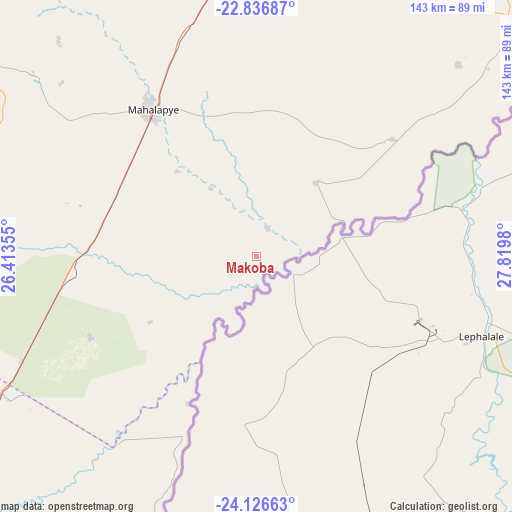
Makoba GPS coordinates[2]
23° 28' 59.988" South, 27° 7' 0.012" East
| Map corner | latitude | longitude |
|---|---|---|
| Upper-left | -22.83687°, | 26.41355° |
| Center: | -23.48333°, | 27.11667° |
| Lower-right: | -24.12663°, | 27.8198° |
| Map W x H: | 143.4×143.4 km | = 89.1×89.1mi |
| max Lat: | -17.80165° ⇑55.2% North |
| Makoba: | -23.48333° |
| min Lat: | ⇓44.8% South -26.9° |
| min Long | Makoba | max Long |
| 20.06667° | 27.11667° | 28.74946° |
| W 72.4%⇐ | ⇒27.6% E |
Elevation
Elevation of Makoba is 848 m = 2782 ft, and this is 167 m = 548 ft below average elevation for this country.
| Max E: |
1406 m = 4613 ft | 94.3% |
| Avg. | 1015 m = 3330 ft | |
| Makoba | 848 m = 2782 ft | |
Min E: |
676 m = 2218 ft | 5.7% |
See also: Botswana elevation on elevation.city.
Geographical zone
Makoba is located in South temperate zone (between Tropic of Capricorn and the Antarctic Circle). Distance of this Southern Tropic circle is 5.2 km =3.2 mi to North.| Distance of | km | miles | from Makoba |
|---|---|---|---|
| Equator | 2611.1 | 1622.5 | to North |
| Tropic Capricorn | 5.2 | 3.2 | to North |
| Antarctic Circle | 4790.1 | 2976.4 | to South |
| South Pole | 7396 | 4595.7 | to South |


Nearby cities:
15 places around Makoba: (largest is in red/bold)
• Bonwapitse
69.5 km =43.2 mi,  315°
315°
• Kalamare
82.8 km =51.4 mi, 317°
• Kurametsi
10.6 km =6.6 mi,  331°
331°
• Letsheng
91.8 km =57 mi,  6°
6°
• Maapi
84.1 km =52.3 mi,  16°
16°
• Machaneng
50.3 km =31.3 mi,  48°
48°
• Magothla
15.1 km =9.4 mi,  232°
232°
• Mahalapye
52.3 km =32.5 mi, 323°
• Makobeng
78.1 km =48.5 mi, 46°
• Makwata
29.1 km =18.1 mi,  40°
40°
• Mathakola
87 km =54.1 mi, 13°
• Mookane
51.9 km =32.2 mi,  243°
243°
• Pilikwe
76.5 km =47.5 mi, 5°
• Ramokgonami
75.6 km =47 mi, 24°
• Shakgwe
42 km =26.1 mi,  4°
4°
Sources, notices
• [Note1] Compared only with cities in Botswana existing in our database
• [Src1] Map data: © OpenStreetMap contributors (CC-BY-SA)
• [Src2] Other city data from geonames.org with taken over terms of usage.
• [Src3] Geographical zone / Annual Mean Temperature by Robert A. Rohde @ Wikipedia
