Yalizava geodata
Yalizava (Mogilev) is a populated place; located in Belarus in Europe/Minsk (GMT+3) time zone. With population of 2,600 people, there are 169 cities with bigger population in this country. Compared to other cities in Belarus, 65.5% of cities are located further ↑North; 69.4% of cities are located further ←West and 65.1% of cities have higher elevation than Yalizava. Note1


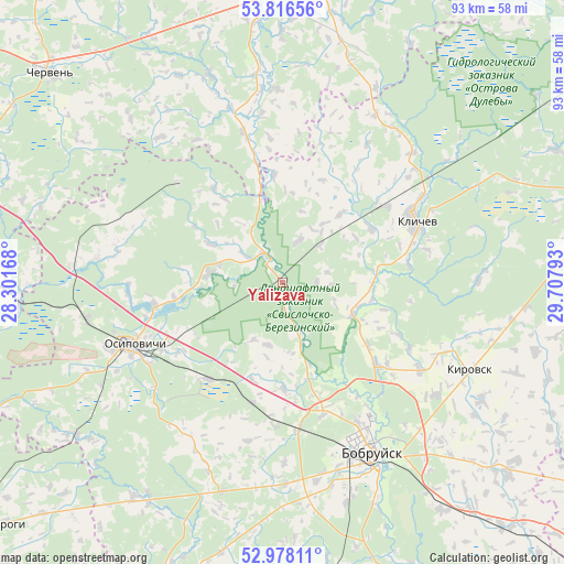
Yalizava GPS coordinates[2]
53° 23' 57.84" North, 29° 0' 17.28" East
| Map corner | latitude | longitude |
|---|---|---|
| Upper-left | 53.81656°, | 28.30168° |
| Center: | 53.3994°, | 29.0048° |
| Lower-right: | 52.97811°, | 29.70793° |
| Map W x H: | 93.2×93.2 km | = 57.9×57.9mi |
| max Lat: | 56.0147° ⇑65.5% North |
| Yalizava: | 53.3994° |
| min Lat: | ⇓34.5% South 51.75° |
| min Long | Yalizava | max Long |
| 23.37083° | 29.0048° | 32.578° |
| W 69.4%⇐ | ⇒30.6% E |
Elevation
Elevation of Yalizava is 151 m = 495 ft, and this is 17.6 m = 58 ft below average elevation for this country.
| Max E: |
309 m = 1014 ft | 65.1% |
| Avg. | 168.6 m = 553 ft | |
| Yalizava | 151 m = 495 ft | |
Min E: |
108 m = 354 ft | 34.9% |
See also: Belarus elevation on elevation.city.
Geographical zone
Yalizava is located in North temperate zone (between Tropic of Cancer and the Arctic Circle). Distance of this North polar circle is 1463.7 km =909.5 mi to North.| Distance of | km | miles | from Yalizava |
|---|---|---|---|
| North Pole | 4069.6 | 2528.7 | to North |
| Arctic Circle | 1463.7 | 909.5 | to North |
| Tropic Cancer | 3331.5 | 2070.1 | to South |
| Equator | 5937.5 | 3689.4 | to South |


Nearby cities:
15 places around Yalizava: (largest is in red/bold)
• Asipovichy
26.6 km =16.5 mi,  245°
245°
• Babruysk
32.4 km =20.1 mi,  153°
153°
• Blon’
56.8 km =35.3 mi,  284°
284°
• Byerazino
48.9 km =30.4 mi,  358°
358°
• Chervyen’
51 km =31.7 mi,  311°
311°
• Hlusha
36.1 km =22.4 mi,  195°
195°
• Kirawsk
34.4 km =21.4 mi,  114°
114°
• Klichaw
24.2 km =15 mi,  64°
64°
• Myshkavichy
39.3 km =24.4 mi,  121°
121°
• Natal’yewsk
52.5 km =32.6 mi, 313°
• Ostrovy
55.2 km =34.3 mi, 312°
• Pahost
50.8 km =31.6 mi,  10°
10°
• Paplavy
46.1 km =28.6 mi,  348°
348°
• Pukhavichy
52.2 km =32.4 mi,  286°
286°
• Tatarka
20.4 km =12.7 mi,  217°
217°
Sources, notices
• [Note1] Compared only with cities in Belarus existing in our database
• [Src1] Map data: © OpenStreetMap contributors (CC-BY-SA)
• [Src2] Other city data from geonames.org with taken over terms of usage.
• [Src3] Geographical zone / Annual Mean Temperature by Robert A. Rohde @ Wikipedia
