Tatarka geodata
Tatarka (Mogilev) is a populated place; located in Belarus in Europe/Minsk (GMT+3) time zone. With population of 770 people, there are 264 cities with bigger population in this country. Compared to other cities in Belarus, 69.1% of cities are located further ↑North; 67.4% of cities are located further ←West and 57.2% of cities have higher elevation than Tatarka. Note1


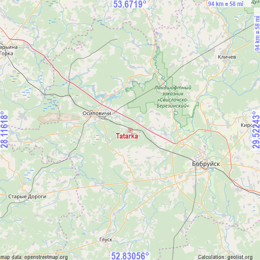
Tatarka GPS coordinates[2]
53° 15' 11.88" North, 28° 49' 9.48" East
| Map corner | latitude | longitude |
|---|---|---|
| Upper-left | 53.6719°, | 28.11618° |
| Center: | 53.2533°, | 28.8193° |
| Lower-right: | 52.83056°, | 29.52243° |
| Map W x H: | 93.5×93.5 km | = 58.1×58.1mi |
| max Lat: | 56.0147° ⇑69.1% North |
| Tatarka: | 53.2533° |
| min Lat: | ⇓30.9% South 51.75° |
| min Long | Tatarka | max Long |
| 23.37083° | 28.8193° | 32.578° |
| W 67.4%⇐ | ⇒32.6% E |
Elevation
Elevation of Tatarka is 159 m = 522 ft, and this is 9.6 m = 31 ft below average elevation for this country.
| Max E: |
309 m = 1014 ft | 57.2% |
| Avg. | 168.6 m = 553 ft | |
| Tatarka | 159 m = 522 ft | |
Min E: |
108 m = 354 ft | 42.8% |
See also: Belarus elevation on elevation.city.
Geographical zone
Tatarka is located in North temperate zone (between Tropic of Cancer and the Arctic Circle). Distance of this North polar circle is 1480 km =919.6 mi to North.| Distance of | km | miles | from Tatarka |
|---|---|---|---|
| North Pole | 4085.9 | 2538.9 | to North |
| Arctic Circle | 1480 | 919.6 | to North |
| Tropic Cancer | 3315.3 | 2060 | to South |
| Equator | 5921.2 | 3679.3 | to South |


Nearby cities:
15 places around Tatarka: (largest is in red/bold)
• Asipovichy
13.1 km =8.1 mi,  293°
293°
• Babruysk
29.7 km =18.5 mi,  115°
115°
• Blon’
52.5 km =32.6 mi,  305°
305°
• Chervyen’
56.5 km =35.1 mi,  332°
332°
• Hlusha
18.7 km =11.6 mi,  172°
172°
• Hlusk
40 km =24.9 mi,  193°
193°
• Kirawsk
43.7 km =27.2 mi,  87°
87°
• Klichaw
43.3 km =26.9 mi,  52°
52°
• Mar’’ina Horka
52.9 km =32.9 mi,  302°
302°
• Myshkavichy
46.3 km =28.8 mi, 94°
• Natal’yewsk
58.6 km =36.4 mi, 334°
• Ostrovy
60.6 km =37.7 mi, 331°
• Pukhavichy
48.8 km =30.3 mi, 308°
• Staryya Darohi
43.8 km =27.2 mi,  237°
237°
• Yalizava
20.4 km =12.7 mi,  37°
37°
Sources, notices
• [Note1] Compared only with cities in Belarus existing in our database
• [Src1] Map data: © OpenStreetMap contributors (CC-BY-SA)
• [Src2] Other city data from geonames.org with taken over terms of usage.
• [Src3] Geographical zone / Annual Mean Temperature by Robert A. Rohde @ Wikipedia
