Klichaw geodata
Klichaw (Mogilev) is a seat of a second-order administrative division; located in Belarus in Europe/Minsk (GMT+3) time zone. With population of 7,200 people, there are 116 cities with bigger population in this country. Compared to other cities in Belarus, 62.2% of cities are located further ↑North; 73% of cities are located further ←West and 62.8% of cities have higher elevation than Klichaw. Note1


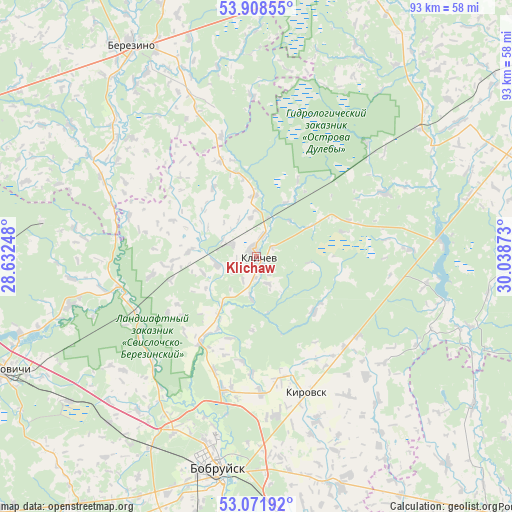
Klichaw GPS coordinates[2]
53° 29' 32.28" North, 29° 20' 8.16" East
| Map corner | latitude | longitude |
|---|---|---|
| Upper-left | 53.90855°, | 28.63248° |
| Center: | 53.4923°, | 29.3356° |
| Lower-right: | 53.07192°, | 30.03873° |
| Map W x H: | 93×93 km | = 57.8×57.8mi |
| max Lat: | 56.0147° ⇑62.2% North |
| Klichaw: | 53.4923° |
| min Lat: | ⇓37.8% South 51.75° |
| min Long | Klichaw | max Long |
| 23.37083° | 29.3356° | 32.578° |
| W 73%⇐ | ⇒27% E |
Elevation
Elevation of Klichaw is 154 m = 505 ft, and this is 14.6 m = 48 ft below average elevation for this country.
| Max E: |
309 m = 1014 ft | 62.8% |
| Avg. | 168.6 m = 553 ft | |
| Klichaw | 154 m = 505 ft | |
Min E: |
108 m = 354 ft | 37.2% |
See also: Belarus elevation on elevation.city.
Geographical zone
Klichaw is located in North temperate zone (between Tropic of Cancer and the Arctic Circle). Distance of this North polar circle is 1453.4 km =903.1 mi to North.| Distance of | km | miles | from Klichaw |
|---|---|---|---|
| North Pole | 4059.3 | 2522.3 | to North |
| Arctic Circle | 1453.4 | 903.1 | to North |
| Tropic Cancer | 3341.9 | 2076.6 | to South |
| Equator | 5947.8 | 3695.8 | to South |


Nearby cities:
15 places around Klichaw: (largest is in red/bold)
• Asipovichy
50.9 km =31.6 mi,  245°
245°
• Babruysk
40.1 km =24.9 mi,  190°
190°
• Byalynichy
61.6 km =38.3 mi,  23°
23°
• Byerazino
44.9 km =27.9 mi,  329°
329°
• Bykhaw
60.2 km =37.4 mi,  86°
86°
• Hlusha
55.2 km =34.3 mi,  215°
215°
• Kirawsk
26.5 km =16.5 mi,  159°
159°
• Krasnyy Bereg
59.6 km =37 mi,  107°
107°
• Myazhysyatki
63.9 km =39.7 mi,  60°
60°
• Myshkavichy
32.8 km =20.4 mi, 159°
• Pahost
41.4 km =25.7 mi,  342°
342°
• Paplavy
46.5 km =28.9 mi,  318°
318°
• Tatarka
43.3 km =26.9 mi,  232°
232°
• Vyalikaya Mashchanitsa
54.8 km =34.1 mi, 20°
• Yalizava
24.2 km =15 mi,  244°
244°
Sources, notices
• [Note1] Compared only with cities in Belarus existing in our database
• [Src1] Map data: © OpenStreetMap contributors (CC-BY-SA)
• [Src2] Other city data from geonames.org with taken over terms of usage.
• [Src3] Geographical zone / Annual Mean Temperature by Robert A. Rohde @ Wikipedia
